Mliiv geodata
Mliiv (Cherkasy) is a populated place; located in Ukraine in Europe/Kiev (GMT+3) time zone. With population of 4,158 people, there are 744 cities with bigger population in this country. Compared to other cities in Ukraine, 71.5% of cities are located further ↓South; 59.2% of cities are located further →East and 65.1% of cities have higher elevation than Mliiv. Note1


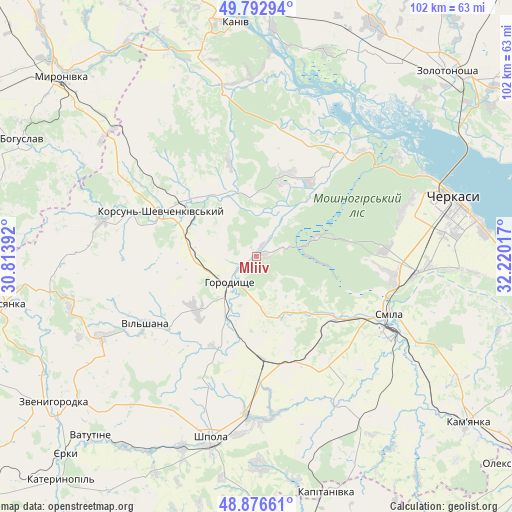
Mliiv GPS coordinates[2]
49° 20' 12.876" North, 31° 31' 1.344" East
| Map corner | latitude | longitude |
|---|---|---|
| Upper-left | 49.79294°, | 30.81392° |
| Center: | 49.33691°, | 31.51704° |
| Lower-right: | 48.87661°, | 32.22017° |
| Map W x H: | 101.9×101.9 km | = 63.3×63.3mi |
| max Lat: | 52.18903° ⇑28.5% North |
| Mliiv: | 49.33691° |
| min Lat: | ⇓71.5% South 44.39214° |
| min Long | Mliiv | max Long |
| 22.20555° | 31.51704° | 40.13222° |
| W 40.8%⇐ | ⇒59.2% E |
Elevation
Elevation of Mliiv is 90 m = 295 ft, and this is 65.8 m = 216 ft below average elevation for this country.
| Max E: |
886 m = 2907 ft | 65.1% |
| Avg. | 155.8 m = 511 ft | |
| Mliiv | 90 m = 295 ft | |
Min E: |
-3 m = -10 ft | 34.9% |
See also: Ukraine elevation on elevation.city.
Geographical zone
Mliiv is located in North temperate zone (between Tropic of Cancer and the Arctic Circle). Distance of this North polar circle is 1915.4 km =1190.2 mi to North.| Distance of | km | miles | from Mliiv |
|---|---|---|---|
| North Pole | 4521.3 | 2809.4 | to North |
| Arctic Circle | 1915.4 | 1190.2 | to North |
| Tropic Cancer | 2879.8 | 1789.4 | to South |
| Equator | 5485.8 | 3408.7 | to South |


Nearby cities:
15 places around Mliiv: (largest is in red/bold)
• Cherkasy
40.7 km =25.3 mi,  75°
75°
• Chervona Sloboda
46.6 km =29 mi,  85°
85°
• Horodyshche
7.8 km =4.8 mi,  222°
222°
• Kaniv
46.3 km =28.8 mi,  354°
354°
• Kapitanivka
48.9 km =30.4 mi,  162°
162°
• Korsun-Shevchenkivskyi
20.8 km =12.9 mi,  295°
295°
• Lebedyn
41.6 km =25.8 mi,  179°
179°
• Moshny
26.5 km =16.5 mi,  36°
36°
• Ruska Poliana
30.5 km =19 mi,  73°
73°
• Shpola
37.8 km =23.5 mi,  193°
193°
• Smila
29.7 km =18.5 mi,  115°
115°
• Stebliv
31.2 km =19.4 mi,  283°
283°
• Tsvitkove
20.6 km =12.8 mi, 175°
• Vatutine
48.7 km =30.3 mi, 222°
• Yurkivka
47.8 km =29.7 mi, 220°
Sources, notices
• [Note1] Compared only with cities in Ukraine existing in our database
• [Src1] Map data: © OpenStreetMap contributors (CC-BY-SA)
• [Src2] Other city data from geonames.org with taken over terms of usage.
• [Src3] Geographical zone / Annual Mean Temperature by Robert A. Rohde @ Wikipedia
