Kamianka geodata
Kamianka (Cherkasy) is a seat of a second-order administrative division; located in Ukraine in Europe/Kiev (GMT+3) time zone. With population of 14,547 people, there are 261 cities with bigger population in this country. Compared to other cities in Ukraine, 67.1% of cities are located further ↓South; 57% of cities are located further →East and 52.2% of cities have higher elevation than Kamianka. Note1


Kamianka GPS coordinates[2]
49° 1' 54.48" North, 32° 6' 14.256" East
| Map corner | latitude | longitude |
|---|---|---|
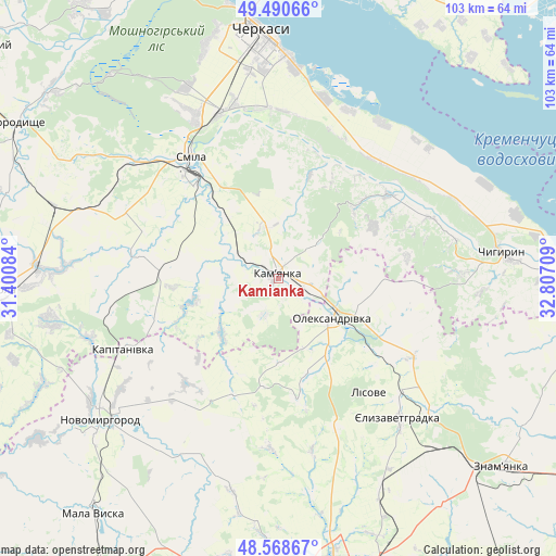
| Upper-left | 49.49066°, | 31.40084° |
| Center: | 49.0318°, | 32.10396° |
| Lower-right: | 48.56867°, | 32.80709° |
| Map W x H: | 102.5×102.5 km | = 63.7×63.7mi |
| max Lat: | 52.18903° ⇑32.9% North |
| Kamianka: | 49.0318° |
| min Lat: | ⇓67.1% South 44.39214° |
| min Long | Kamianka | max Long |
| 22.20555° | 32.10396° | 40.13222° |
| W 43%⇐ | ⇒57% E |
Elevation
Elevation of Kamianka is 127 m = 417 ft, and this is 28.8 m = 94 ft below average elevation for this country.
| Max E: |
886 m = 2907 ft | 52.2% |
| Avg. | 155.8 m = 511 ft | |
| Kamianka | 127 m = 417 ft | |
Min E: |
-3 m = -10 ft | 47.8% |
See also: Ukraine elevation on elevation.city.
Geographical zone
Kamianka is located in North temperate zone (between Tropic of Cancer and the Arctic Circle). Distance of this North polar circle is 1949.3 km =1211.2 mi to North.| Distance of | km | miles | from Kamianka |
|---|---|---|---|
| North Pole | 4555.2 | 2830.5 | to North |
| Arctic Circle | 1949.3 | 1211.2 | to North |
| Tropic Cancer | 2845.9 | 1768.4 | to South |
| Equator | 5451.8 | 3387.6 | to South |


Nearby cities:
15 places around Kamianka: (largest is in red/bold)
• Cherkasy
44.2 km =27.5 mi,  356°
356°
• Chervona Sloboda
38.1 km =23.7 mi,  5°
5°
• Chyhyryn
40.6 km =25.2 mi,  81°
81°
• Dmytrivka
51.8 km =32.2 mi,  120°
120°
• Kapitanivka
31 km =19.3 mi,  245°
245°
• Lebedyn
42.8 km =26.6 mi,  259°
259°
• Novomyrhorod
43.8 km =27.2 mi,  230°
230°
• Oleksandrivka
12.2 km =7.6 mi,  128°
128°
• Ruska Poliana
44.9 km =27.9 mi,  342°
342°
• Shpola
51.8 km =32.2 mi,  266°
266°
• Smila
26.4 km =16.4 mi,  323°
323°
• Subottsi
51.8 km =32.2 mi,  143°
143°
• Tsvitkove
43.4 km =27 mi,  287°
287°
• Yelyzavethradka
33.5 km =20.8 mi, 139°
• Znomenka
54.2 km =33.7 mi, 130°
Sources, notices
• [Note1] Compared only with cities in Ukraine existing in our database
• [Src1] Map data: © OpenStreetMap contributors (CC-BY-SA)
• [Src2] Other city data from geonames.org with taken over terms of usage.
• [Src3] Geographical zone / Annual Mean Temperature by Robert A. Rohde @ Wikipedia
