Yelyzavethradka geodata
Yelyzavethradka (Kirovohrad) is a populated place; located in Ukraine in Europe/Kiev (GMT+3) time zone. With population of 1,673 people, there are 1177 cities with bigger population in this country. Compared to other cities in Ukraine, 62.1% of cities are located further ↓South; 55.8% of cities are located further →East and 58.1% of cities have lower elevation than Yelyzavethradka. Note1


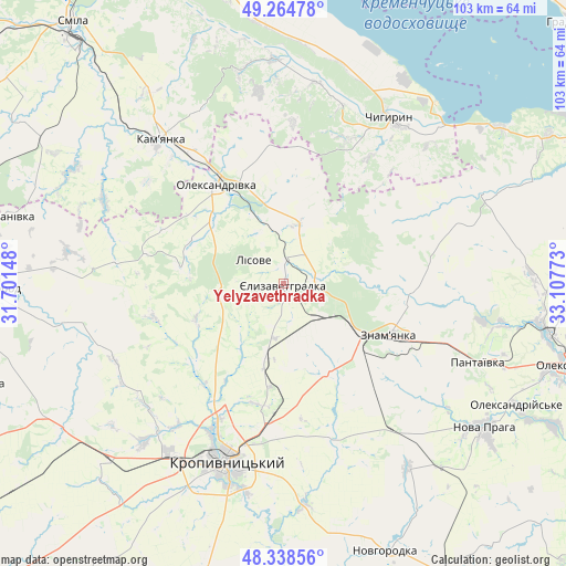
Yelyzavethradka GPS coordinates[2]
48° 48' 13.716" North, 32° 24' 16.56" East
| Map corner | latitude | longitude |
|---|---|---|
| Upper-left | 49.26478°, | 31.70148° |
| Center: | 48.80381°, | 32.4046° |
| Lower-right: | 48.33856°, | 33.10773° |
| Map W x H: | 103×103 km | = 64×64mi |
| max Lat: | 52.18903° ⇑37.9% North |
| Yelyzavethradka: | 48.80381° |
| min Lat: | ⇓62.1% South 44.39214° |
| min Long | Yelyzavethradka | max Long |
| 22.20555° | 32.4046° | 40.13222° |
| W 44.2%⇐ | ⇒55.8% E |
Elevation
Elevation of Yelyzavethradka is 161 m = 528 ft, and this is 5.2 m = 17 ft above average elevation for this country.
| Max E: |
886 m = 2907 ft | 41.9% |
| Yelyzavethradka | 161 m 528 ft | |
| Avg. | 155.8 m = 511 ft | |
Min E: |
-3 m = -10 ft | 58.1% |
See also: Ukraine elevation on elevation.city.
Geographical zone
Yelyzavethradka is located in North temperate zone (between Tropic of Cancer and the Arctic Circle). Distance of this North polar circle is 1974.7 km =1227 mi to North.| Distance of | km | miles | from Yelyzavethradka |
|---|---|---|---|
| North Pole | 4580.6 | 2846.3 | to North |
| Arctic Circle | 1974.7 | 1227 | to North |
| Tropic Cancer | 2820.6 | 1752.6 | to South |
| Equator | 5426.5 | 3371.9 | to South |


Nearby cities:
15 places around Yelyzavethradka: (largest is in red/bold)
• Adzhamka
30.6 km =19 mi,  161°
161°
• Chyhyryn
36.1 km =22.4 mi,  30°
30°
• Dmytrivka
22.9 km =14.2 mi,  91°
91°
• Kamianka
33.5 km =20.8 mi,  319°
319°
• Kapitanivka
51.9 km =32.2 mi,  284°
284°
• Kropyvnytskyi
34 km =21.1 mi,  198°
198°
• Nova Praha
45 km =28 mi,  125°
125°
• Novhorodka
52.2 km =32.4 mi, 159°
• Oleksandrivka
21.6 km =13.4 mi,  325°
325°
• Oleksandriya
54.3 km =33.7 mi,  105°
105°
• Oleksandriys’ke
47.7 km =29.6 mi,  117°
117°
• Pantayivka
38 km =23.6 mi, 112°
• Pryyutivka
49.7 km =30.9 mi,  100°
100°
• Subottsi
18.6 km =11.6 mi,  152°
152°
• Znomenka
21.6 km =13.4 mi, 117°
Sources, notices
• [Note1] Compared only with cities in Ukraine existing in our database
• [Src1] Map data: © OpenStreetMap contributors (CC-BY-SA)
• [Src2] Other city data from geonames.org with taken over terms of usage.
• [Src3] Geographical zone / Annual Mean Temperature by Robert A. Rohde @ Wikipedia
