Domanivka geodata
Domanivka (Mykolaiv) is a seat of a second-order administrative division; located in Ukraine in Europe/Kiev (GMT+3) time zone. With population of 6,517 people, there are 539 cities with bigger population in this country. Compared to other cities in Ukraine, 59.9% of cities are located further ↑North; 61.1% of cities are located further →East and 71.4% of cities have higher elevation than Domanivka. Note1


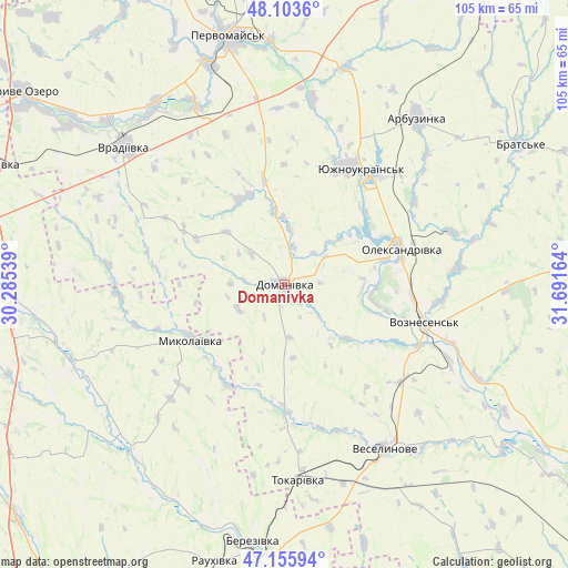
Domanivka GPS coordinates[2]
47° 37' 54.912" North, 30° 59' 18.636" East
| Map corner | latitude | longitude |
|---|---|---|
| Upper-left | 48.1036°, | 30.28539° |
| Center: | 47.63192°, | 30.98851° |
| Lower-right: | 47.15594°, | 31.69164° |
| Map W x H: | 105.4×105.4 km | = 65.5×65.5mi |
| max Lat: | 52.18903° ⇑59.9% North |
| Domanivka: | 47.63192° |
| min Lat: | ⇓40.1% South 44.39214° |
| min Long | Domanivka | max Long |
| 22.20555° | 30.98851° | 40.13222° |
| W 38.9%⇐ | ⇒61.1% E |
Elevation
Elevation of Domanivka is 71 m = 233 ft, and this is 84.8 m = 278 ft below average elevation for this country.
| Max E: |
886 m = 2907 ft | 71.4% |
| Avg. | 155.8 m = 511 ft | |
| Domanivka | 71 m = 233 ft | |
Min E: |
-3 m = -10 ft | 28.6% |
See also: Ukraine elevation on elevation.city.
Geographical zone
Domanivka is located in North temperate zone (between Tropic of Cancer and the Arctic Circle). Distance of this North polar circle is 2105 km =1308 mi to North.| Distance of | km | miles | from Domanivka |
|---|---|---|---|
| North Pole | 4710.9 | 2927.2 | to North |
| Arctic Circle | 2105 | 1308 | to North |
| Tropic Cancer | 2690.3 | 1671.7 | to South |
| Equator | 5296.2 | 3290.9 | to South |


Nearby cities:
15 places around Domanivka: (largest is in red/bold)
• Arbuzynka
39.6 km =24.6 mi,  38°
38°
• Berezivka
47.9 km =29.8 mi,  187°
187°
• Brats’ke
51.4 km =31.9 mi,  59°
59°
• Kostyantynivka
24.3 km =15.1 mi,  26°
26°
• Kryve Ozero
59.6 km =37 mi,  306°
306°
• Lysa Hora
60.6 km =37.7 mi,  8°
8°
• Lyubashivka
59.1 km =36.7 mi,  292°
292°
• Myhiya
45.1 km =28 mi,  356°
356°
• Mykolayivka
20.1 km =12.5 mi,  239°
239°
• Pervomays’k
47 km =29.2 mi,  347°
347°
• Pidhorodna
53.3 km =33.1 mi, 352°
• Veselynove
35.8 km =22.2 mi,  148°
148°
• Voznesensk
26.7 km =16.6 mi,  106°
106°
• Vradiyivka
39.2 km =24.4 mi, 310°
• Yuzhnoukrains'k
25.3 km =15.7 mi, 35°
Sources, notices
• [Note1] Compared only with cities in Ukraine existing in our database
• [Src1] Map data: © OpenStreetMap contributors (CC-BY-SA)
• [Src2] Other city data from geonames.org with taken over terms of usage.
• [Src3] Geographical zone / Annual Mean Temperature by Robert A. Rohde @ Wikipedia
