Lysa Hora geodata
Lysa Hora (Mykolaiv) is a populated place; located in Ukraine in Europe/Kiev (GMT+3) time zone. With population of 4,312 people, there are 720 cities with bigger population in this country. Compared to other cities in Ukraine, 52.9% of cities are located further ↑North; 60.6% of cities are located further →East and 60.6% of cities have higher elevation than Lysa Hora. Note1


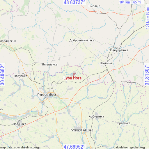
Lysa Hora GPS coordinates[2]
48° 10' 14.124" North, 31° 6' 35.784" East
| Map corner | latitude | longitude |
|---|---|---|
| Upper-left | 48.63737°, | 30.40682° |
| Center: | 48.17059°, | 31.10994° |
| Lower-right: | 47.69952°, | 31.81307° |
| Map W x H: | 104.3×104.3 km | = 64.8×64.8mi |
| max Lat: | 52.18903° ⇑52.9% North |
| Lysa Hora: | 48.17059° |
| min Lat: | ⇓47.1% South 44.39214° |
| min Long | Lysa Hora | max Long |
| 22.20555° | 31.10994° | 40.13222° |
| W 39.4%⇐ | ⇒60.6% E |
Elevation
Elevation of Lysa Hora is 104 m = 341 ft, and this is 51.8 m = 170 ft below average elevation for this country.
| Max E: |
886 m = 2907 ft | 60.6% |
| Avg. | 155.8 m = 511 ft | |
| Lysa Hora | 104 m = 341 ft | |
Min E: |
-3 m = -10 ft | 39.4% |
See also: Ukraine elevation on elevation.city.
Geographical zone
Lysa Hora is located in North temperate zone (between Tropic of Cancer and the Arctic Circle). Distance of this North polar circle is 2045.1 km =1270.8 mi to North.| Distance of | km | miles | from Lysa Hora |
|---|---|---|---|
| North Pole | 4651 | 2890 | to North |
| Arctic Circle | 2045.1 | 1270.8 | to North |
| Tropic Cancer | 2750.1 | 1708.8 | to South |
| Equator | 5356.1 | 3328.1 | to South |


Nearby cities:
15 places around Lysa Hora: (largest is in red/bold)
• Arbuzynka
32.9 km =20.4 mi,  151°
151°
• Dobrovelychkivka
24.7 km =15.3 mi,  12°
12°
• Kostyantynivka
38.3 km =23.8 mi,  177°
177°
• Lypnyazhka
30.8 km =19.1 mi,  355°
355°
• Myhiya
18.9 km =11.7 mi,  218°
218°
• Novoukrayinka
35.5 km =22.1 mi,  60°
60°
• Pervomays’k
23.8 km =14.8 mi,  233°
233°
• Pidhorodna
17.8 km =11.1 mi,  246°
246°
• Pobugskoye
38.4 km =23.9 mi,  269°
269°
• Pomichna
24 km =14.9 mi,  70°
70°
• Rivne
48.5 km =30.1 mi,  79°
79°
• Tyshkivka
38.3 km =23.8 mi,  341°
341°
• Vil’shanka
18.8 km =11.7 mi,  292°
292°
• Yuzhnoukrains'k
39.6 km =24.6 mi,  172°
172°
• Zlynka
47.2 km =29.3 mi,  42°
42°
Sources, notices
• [Note1] Compared only with cities in Ukraine existing in our database
• [Src1] Map data: © OpenStreetMap contributors (CC-BY-SA)
• [Src2] Other city data from geonames.org with taken over terms of usage.
• [Src3] Geographical zone / Annual Mean Temperature by Robert A. Rohde @ Wikipedia
