Brats’ke geodata
Brats’ke (Mykolaiv) is a seat of a second-order administrative division; located in Ukraine in Europe/Kiev (GMT+3) time zone. In our database, there are 1661 cities with bigger population. Compared to other cities in Ukraine, 58% of cities are located further ↑North; 58.7% of cities are located further →East and 62.1% of cities have higher elevation than Brats’ke. Note1


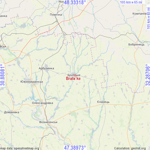
Brats’ke GPS coordinates[2]
47° 51' 48.96" North, 31° 35' 2.148" East
| Map corner | latitude | longitude |
|---|---|---|
| Upper-left | 48.33318°, | 30.88081° |
| Center: | 47.8636°, | 31.58393° |
| Lower-right: | 47.38973°, | 32.28706° |
| Map W x H: | 104.9×104.9 km | = 65.2×65.2mi |
| max Lat: | 52.18903° ⇑58% North |
| Brats’ke: | 47.8636° |
| min Lat: | ⇓42% South 44.39214° |
| min Long | Brats’ke | max Long |
| 22.20555° | 31.58393° | 40.13222° |
| W 41.3%⇐ | ⇒58.7% E |
Elevation
Elevation of Brats’ke is 100 m = 328 ft, and this is 55.8 m = 183 ft below average elevation for this country.
| Max E: |
886 m = 2907 ft | 62.1% |
| Avg. | 155.8 m = 511 ft | |
| Brats’ke | 100 m = 328 ft | |
Min E: |
-3 m = -10 ft | 37.9% |
See also: Ukraine elevation on elevation.city.
Geographical zone
Brats’ke is located in North temperate zone (between Tropic of Cancer and the Arctic Circle). Distance of this North polar circle is 2079.2 km =1292 mi to North.| Distance of | km | miles | from Brats’ke |
|---|---|---|---|
| North Pole | 4685.1 | 2911.2 | to North |
| Arctic Circle | 2079.2 | 1292 | to North |
| Tropic Cancer | 2716 | 1687.6 | to South |
| Equator | 5321.9 | 3306.9 | to South |


Nearby cities:
15 places around Brats’ke: (largest is in red/bold)
• Arbuzynka
20.4 km =12.7 mi,  284°
284°
• Bobrynets
48.5 km =30.1 mi,  63°
63°
• Domanivka
51.4 km =31.9 mi,  239°
239°
• Kostyantynivka
33.7 km =20.9 mi,  262°
262°
• Lysa Hora
49.1 km =30.5 mi,  314°
314°
• Myhiya
50.9 km =31.6 mi,  292°
292°
• Novoukrayinka
51.6 km =32.1 mi,  355°
355°
• Pervomays’k
58.2 km =36.2 mi, 290°
• Pidhorodna
58.3 km =36.2 mi,  297°
297°
• Pomichna
43.9 km =27.3 mi,  343°
343°
• Rivne
44.5 km =27.7 mi,  16°
16°
• Veselynove
62.1 km =38.6 mi,  204°
204°
• Voznesensk
38.2 km =23.7 mi,  209°
209°
• Yelanets’
27.3 km =17 mi,  132°
132°
• Yuzhnoukrains'k
30.4 km =18.9 mi, 260°
Sources, notices
• [Note1] Compared only with cities in Ukraine existing in our database
• [Src1] Map data: © OpenStreetMap contributors (CC-BY-SA)
• [Src2] Other city data from geonames.org with taken over terms of usage.
• [Src3] Geographical zone / Annual Mean Temperature by Robert A. Rohde @ Wikipedia
