Yuzhnoukrains'k geodata
Yuzhnoukrains'k (Mykolaiv) is a populated place; located in Ukraine in Europe/Kiev (GMT+3) time zone. With population of 39,430 people, there are 114 cities with bigger population in this country. Compared to other cities in Ukraine, 58.5% of cities are located further ↑North; 60.3% of cities are located further →East and 65.8% of cities have higher elevation than Yuzhnoukrains'k. Note1


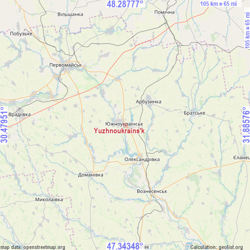
Yuzhnoukrains'k GPS coordinates[2]
47° 49' 3.972" North, 31° 10' 57.468" East
| Map corner | latitude | longitude |
|---|---|---|
| Upper-left | 48.28777°, | 30.47951° |
| Center: | 47.81777°, | 31.18263° |
| Lower-right: | 47.34348°, | 31.88576° |
| Map W x H: | 105×105 km | = 65.2×65.2mi |
| max Lat: | 52.18903° ⇑58.5% North |
| Yuzhnoukrains'k: | 47.81777° |
| min Lat: | ⇓41.5% South 44.39214° |
| min Long | Yuzhnoukrains'k | max Long |
| 22.20555° | 31.18263° | 40.13222° |
| W 39.7%⇐ | ⇒60.3% E |
Elevation
Elevation of Yuzhnoukrains'k is 87 m = 285 ft, and this is 68.8 m = 226 ft below average elevation for this country.
| Max E: |
886 m = 2907 ft | 65.8% |
| Avg. | 155.8 m = 511 ft | |
| Yuzhnoukrains'k | 87 m = 285 ft | |
Min E: |
-3 m = -10 ft | 34.2% |
See also: Ukraine elevation on elevation.city.
Geographical zone
Yuzhnoukrains'k is located in North temperate zone (between Tropic of Cancer and the Arctic Circle). Distance of this North polar circle is 2084.3 km =1295.1 mi to North.| Distance of | km | miles | from Yuzhnoukrains'k |
|---|---|---|---|
| North Pole | 4690.2 | 2914.4 | to North |
| Arctic Circle | 2084.3 | 1295.1 | to North |
| Tropic Cancer | 2710.9 | 1684.5 | to South |
| Equator | 5316.8 | 3303.7 | to South |


Nearby cities:
15 places around Yuzhnoukrains'k: (largest is in red/bold)
• Arbuzynka
14.5 km =9 mi,  44°
44°
• Brats’ke
30.4 km =18.9 mi,  80°
80°
• Domanivka
25.3 km =15.7 mi,  215°
215°
• Kostyantynivka
3.7 km =2.3 mi,  285°
285°
• Lysa Hora
39.6 km =24.6 mi,  352°
352°
• Myhiya
29.9 km =18.6 mi,  324°
324°
• Mykolayivka
44.3 km =27.5 mi,  226°
226°
• Pervomays’k
35.3 km =21.9 mi, 315°
• Pidhorodna
38.9 km =24.2 mi,  325°
325°
• Pomichna
50.3 km =31.3 mi,  20°
20°
• Veselynove
51.4 km =31.9 mi,  175°
175°
• Vil’shanka
51.8 km =32.2 mi, 333°
• Voznesensk
30.2 km =18.8 mi,  158°
158°
• Vradiyivka
44.4 km =27.6 mi,  276°
276°
• Yelanets’
51.8 km =32.2 mi,  105°
105°
Sources, notices
• [Note1] Compared only with cities in Ukraine existing in our database
• [Src1] Map data: © OpenStreetMap contributors (CC-BY-SA)
• [Src2] Other city data from geonames.org with taken over terms of usage.
• [Src3] Geographical zone / Annual Mean Temperature by Robert A. Rohde @ Wikipedia
