Kalynove geodata
Kalynove (Kyiv) is a populated place; located in Ukraine in Europe/Kiev (GMT+3) time zone. With population of 3,042 people, there are 932 cities with bigger population in this country. Compared to other cities in Ukraine, 72.2% of cities are located further ↓South; 64.8% of cities are located further →East and 61.6% of cities have lower elevation than Kalynove. Note1


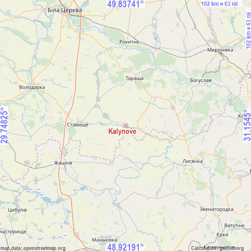
Kalynove GPS coordinates[2]
49° 22' 54.444" North, 30° 27' 4.932" East
| Map corner | latitude | longitude |
|---|---|---|
| Upper-left | 49.83741°, | 29.74825° |
| Center: | 49.38179°, | 30.45137° |
| Lower-right: | 48.92191°, | 31.1545° |
| Map W x H: | 101.8×101.8 km | = 63.3×63.3mi |
| max Lat: | 52.18903° ⇑27.8% North |
| Kalynove: | 49.38179° |
| min Lat: | ⇓72.2% South 44.39214° |
| min Long | Kalynove | max Long |
| 22.20555° | 30.45137° | 40.13222° |
| W 35.2%⇐ | ⇒64.8% E |
Elevation
Elevation of Kalynove is 174 m = 571 ft, and this is 18.2 m = 60 ft above average elevation for this country.
| Max E: |
886 m = 2907 ft | 38.4% |
| Kalynove | 174 m 571 ft | |
| Avg. | 155.8 m = 511 ft | |
Min E: |
-3 m = -10 ft | 61.6% |
See also: Ukraine elevation on elevation.city.
Geographical zone
Kalynove is located in North temperate zone (between Tropic of Cancer and the Arctic Circle). Distance of this North polar circle is 1910.4 km =1187.1 mi to North.| Distance of | km | miles | from Kalynove |
|---|---|---|---|
| North Pole | 4516.3 | 2806.3 | to North |
| Arctic Circle | 1910.4 | 1187.1 | to North |
| Tropic Cancer | 2884.8 | 1792.5 | to South |
| Equator | 5490.7 | 3411.8 | to South |


Nearby cities:
15 places around Kalynove: (largest is in red/bold)
• Bohuslav
35.8 km =22.2 mi,  58°
58°
• Buky
32.4 km =20.1 mi,  186°
186°
• Karapyshi
37.9 km =23.5 mi,  40°
40°
• Lobachiv
40.8 km =25.4 mi,  277°
277°
• Lysianka
31 km =19.3 mi,  117°
117°
• Mankivka
47.3 km =29.4 mi, 190°
• Myronivka
49.3 km =30.6 mi,  51°
51°
• Rokytne
33.9 km =21.1 mi,  2°
2°
• Roskoshnyy
19.3 km =12 mi,  266°
266°
• Stavyshche
18.9 km =11.7 mi, 273°
• Stebliv
46.8 km =29.1 mi,  87°
87°
• Tarashcha
19.9 km =12.4 mi,  8°
8°
• Uzyn
49.5 km =30.8 mi,  356°
356°
• Volodarka
42.1 km =26.2 mi,  292°
292°
• Zhashkiv
29 km =18 mi,  238°
238°
Sources, notices
• [Note1] Compared only with cities in Ukraine existing in our database
• [Src1] Map data: © OpenStreetMap contributors (CC-BY-SA)
• [Src2] Other city data from geonames.org with taken over terms of usage.
• [Src3] Geographical zone / Annual Mean Temperature by Robert A. Rohde @ Wikipedia
