Roskoshnyy geodata
Roskoshnyy (Kyiv) is a populated place; located in Ukraine in Europe/Kiev (GMT+3) time zone. With population of 3,140 people, there are 903 cities with bigger population in this country. Compared to other cities in Ukraine, 71.8% of cities are located further ↓South; 66.9% of cities are located further →East and 78.3% of cities have lower elevation than Roskoshnyy. Note1


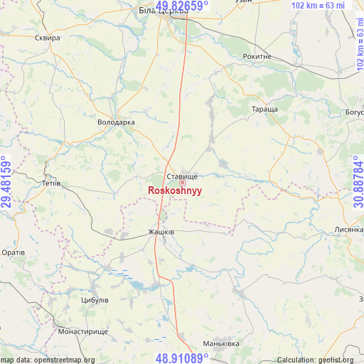
Roskoshnyy GPS coordinates[2]
49° 22' 15.132" North, 30° 11' 4.956" East
| Map corner | latitude | longitude |
|---|---|---|
| Upper-left | 49.82659°, | 29.48159° |
| Center: | 49.37087°, | 30.18471° |
| Lower-right: | 48.91089°, | 30.88784° |
| Map W x H: | 101.8×101.8 km | = 63.3×63.3mi |
| max Lat: | 52.18903° ⇑28.2% North |
| Roskoshnyy: | 49.37087° |
| min Lat: | ⇓71.8% South 44.39214° |
| min Long | Roskoshnyy | max Long |
| 22.20555° | 30.18471° | 40.13222° |
| W 33.1%⇐ | ⇒66.9% E |
Elevation
Elevation of Roskoshnyy is 240 m = 787 ft, and this is 84.2 m = 276 ft above average elevation for this country.
| Max E: |
886 m = 2907 ft | 21.7% |
| Roskoshnyy | 240 m 787 ft | |
| Avg. | 155.8 m = 511 ft | |
Min E: |
-3 m = -10 ft | 78.3% |
See also: Ukraine elevation on elevation.city.
Geographical zone
Roskoshnyy is located in North temperate zone (between Tropic of Cancer and the Arctic Circle). Distance of this North polar circle is 1911.6 km =1187.8 mi to North.| Distance of | km | miles | from Roskoshnyy |
|---|---|---|---|
| North Pole | 4517.5 | 2807 | to North |
| Arctic Circle | 1911.6 | 1187.8 | to North |
| Tropic Cancer | 2883.6 | 1791.8 | to South |
| Equator | 5489.5 | 3411 | to South |


Nearby cities:
15 places around Roskoshnyy: (largest is in red/bold)
• Bila Tserkva
49 km =30.4 mi,  353°
353°
• Buky
34.8 km =21.6 mi,  152°
152°
• Kalynove
19.3 km =12 mi,  86°
86°
• Lobachiv
22.2 km =13.8 mi,  287°
287°
• Lysianka
48.6 km =30.2 mi,  105°
105°
• Mankivka
46.6 km =29 mi,  166°
166°
• Monastyryshche
50.5 km =31.4 mi,  213°
213°
• Nove-Misto
50.5 km =31.4 mi, 210°
• Rokytne
40.8 km =25.4 mi,  30°
30°
• Stavyshche
2.3 km =1.4 mi,  9°
9°
• Tarashcha
30.5 km =19 mi,  46°
46°
• Tetiiv
37.7 km =23.4 mi,  270°
270°
• Tsibulev
40.7 km =25.3 mi,  217°
217°
• Volodarka
26.1 km =16.2 mi,  310°
310°
• Zhashkiv
15 km =9.3 mi,  201°
201°
Sources, notices
• [Note1] Compared only with cities in Ukraine existing in our database
• [Src1] Map data: © OpenStreetMap contributors (CC-BY-SA)
• [Src2] Other city data from geonames.org with taken over terms of usage.
• [Src3] Geographical zone / Annual Mean Temperature by Robert A. Rohde @ Wikipedia
