Pavlivka geodata
Pavlivka (Odesa) is a populated place; located in Ukraine in Europe/Kiev (GMT+3) time zone. With population of 738 people, there are 1516 cities with bigger population in this country. Compared to other cities in Ukraine, 65.3% of cities are located further ↑North; 67.8% of cities are located further →East and 98.6% of cities have higher elevation than Pavlivka. Note1


Pavlivka GPS coordinates[2]
46° 45' 37.584" North, 29° 59' 12.588" East
| Map corner | latitude | longitude |
|---|---|---|
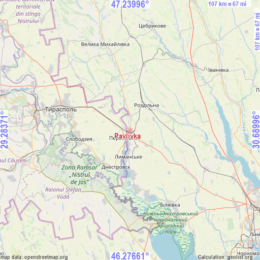
| Upper-left | 47.23996°, | 29.28371° |
| Center: | 46.76044°, | 29.98683° |
| Lower-right: | 46.27661°, | 30.68996° |
| Map W x H: | 107.1×107.1 km | = 66.5×66.5mi |
| max Lat: | 52.18903° ⇑65.3% North |
| Pavlivka: | 46.76044° |
| min Lat: | ⇓34.7% South 44.39214° |
| min Long | Pavlivka | max Long |
| 22.20555° | 29.98683° | 40.13222° |
| W 32.2%⇐ | ⇒67.8% E |
Elevation
Elevation of Pavlivka is 6 m = 20 ft, and this is 149.8 m = 491 ft below average elevation for this country.
| Max E: |
886 m = 2907 ft | 98.6% |
| Avg. | 155.8 m = 511 ft | |
| Pavlivka | 6 m = 20 ft | |
Min E: |
-3 m = -10 ft | 1.4% |
See also: Ukraine elevation on elevation.city.
Geographical zone
Pavlivka is located in North temperate zone (between Tropic of Cancer and the Arctic Circle). Distance of this North polar circle is 2201.9 km =1368.2 mi to North.| Distance of | km | miles | from Pavlivka |
|---|---|---|---|
| North Pole | 4807.8 | 2987.4 | to North |
| Arctic Circle | 2201.9 | 1368.2 | to North |
| Tropic Cancer | 2593.4 | 1611.5 | to South |
| Equator | 5199.3 | 3230.7 | to South |


Nearby cities:
15 places around Pavlivka: (largest is in red/bold)
• Bilyayivka
35.5 km =22.1 mi,  150°
150°
• Ivanivka
43.8 km =27.2 mi,  56°
56°
• Kamyshevka Vtoraya
59.8 km =37.2 mi,  191°
191°
• Kremidivka
60.9 km =37.8 mi,  92°
92°
• Kuchurhan
47.2 km =29.3 mi,  341°
341°
• Lymanske
11.7 km =7.3 mi, 187°
• Mayaky
44 km =27.3 mi, 150°
• Rozdil’na
11.6 km =7.2 mi,  37°
37°
• Starokozache
47.1 km =29.3 mi,  180°
180°
• Stepanivka
3.8 km =2.4 mi,  0°
0°
• Stepove
9.4 km =5.8 mi,  131°
131°
• Teplodar
38.3 km =23.8 mi,  137°
137°
• Usatove
57.2 km =35.5 mi,  116°
116°
• Velyka Mykhaylivka
36.8 km =22.9 mi, 344°
• Velykoploske
36.9 km =22.9 mi,  319°
319°
Sources, notices
• [Note1] Compared only with cities in Ukraine existing in our database
• [Src1] Map data: © OpenStreetMap contributors (CC-BY-SA)
• [Src2] Other city data from geonames.org with taken over terms of usage.
• [Src3] Geographical zone / Annual Mean Temperature by Robert A. Rohde @ Wikipedia
