Nyachera geodata
Nyachera (Western Region) is a populated place; located in Uganda in Africa/Kampala (GMT+3) time zone. With population of 30,509 people, there are 26 cities with bigger population in this country. Compared to other cities in Uganda, 97.3% of cities are located further ↑North; 87.7% of cities are located further →East and 80.8% of cities have lower elevation than Nyachera. Note1
Administrative division(s):
- Level 1: Western Region
- Level 2: Ntungamo District
- Level 3: Ruhaama
- Level 4: Nyakyera


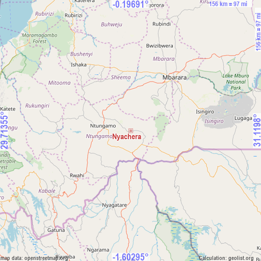
Nyachera GPS coordinates[2]
0° 54' 0" South, 30° 25' 0.012" East
| Map corner | latitude | longitude |
|---|---|---|
| Upper-left | -0.19691°, | 29.71355° |
| Center: | -0.9°, | 30.41667° |
| Lower-right: | -1.60295°, | 31.1198° |
| Map W x H: | 156.3×156.3 km | = 97.1×97.1mi |
| max Lat: | 3.66088° ⇑97.3% North |
| Nyachera: | -0.9° |
| min Lat: | ⇓2.7% South -1.28538° |
| min Long | Nyachera | max Long |
| 29.65° | 30.41667° | 34.95° |
| W 12.3%⇐ | ⇒87.7% E |
Elevation
Elevation of Nyachera is 1407 m = 4616 ft, and this is 148 m = 486 ft above average elevation for this country.
| Max E: |
4129 m = 13547 ft | 19.2% |
| Nyachera | 1407 m 4616 ft | |
| Avg. | 1259 m = 4131 ft | |
Min E: |
622 m = 2041 ft | 80.8% |
See also: Uganda elevation on elevation.city.
Geographical zone
Nyachera is located in South Torrid zone (between Equator and Tropic of Capricorn). Distance of Equator is 100.1 km =62.2 mi to North.| Distance of | km | miles | from Nyachera |
|---|---|---|---|
| Equator | 100.1 | 62.2 | to North |
| Tropic Capricorn | 2505.8 | 1557 | to South |
| Antarctic Circle | 7301.1 | 4536.7 | to South |
| South Pole | 9907 | 6155.9 | to South |


Nearby cities:
15 places around Nyachera: (largest is in red/bold)
• Buhweju
62.5 km =38.8 mi,  348°
348°
• Bushenyi
47.8 km =29.7 mi,  327°
327°
• Bwizibwera
41.6 km =25.8 mi,  34°
34°
• Isingiro
46.1 km =28.6 mi,  85°
85°
• Kabale
61.3 km =38.1 mi,  230°
230°
• Kanungu
70 km =43.5 mi,  264°
264°
• Kibingo
30.5 km =19 mi,  4°
4°
• Mbarara
41.7 km =25.9 mi,  38°
38°
• Mitoma
45.4 km =28.2 mi,  301°
301°
• Nsika
60.3 km =37.5 mi, 1°
• Ntungamo
17.1 km =10.6 mi,  277°
277°
• Ntungamo
85.3 km =53 mi,  271°
271°
• Rubanda
71.1 km =44.2 mi,  243°
243°
• Rubirizi
73.9 km =45.9 mi, 334°
• Rukungiri
53.2 km =33.1 mi, 277°
Sources, notices
• [Note1] Compared only with cities in Uganda existing in our database
• [Src1] Map data: © OpenStreetMap contributors (CC-BY-SA)
• [Src2] Other city data from geonames.org with taken over terms of usage.
• [Src3] Geographical zone / Annual Mean Temperature by Robert A. Rohde @ Wikipedia
