Kabale geodata
Kabale (Western Region) is a seat of a second-order administrative division; located in Uganda in Africa/Kampala (GMT+3) time zone. With population of 43,500 people, there are 16 cities with bigger population in this country. Compared to other cities in Uganda, 99.3% of cities are located further ↑North; 95.2% of cities are located further →East and 95.2% of cities have lower elevation than Kabale. Note1
Administrative division(s):
- Level 1: Western Region
- Level 2: Kabale District
- Level 3: Kabale Municipality
- Level 4: Northern Division


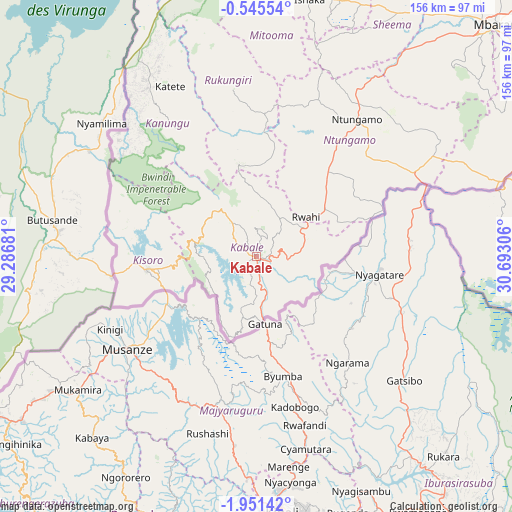
Kabale GPS coordinates[2]
1° 14' 54.852" South, 29° 59' 23.748" East
| Map corner | latitude | longitude |
|---|---|---|
| Upper-left | -0.54554°, | 29.28681° |
| Center: | -1.24857°, | 29.98993° |
| Lower-right: | -1.95142°, | 30.69306° |
| Map W x H: | 156.3×156.3 km | = 97.1×97.1mi |
| max Lat: | 3.66088° ⇑99.3% North |
| Kabale: | -1.24857° |
| min Lat: | ⇓0.7% South -1.28538° |
| min Long | Kabale | max Long |
| 29.65° | 29.98993° | 34.95° |
| W 4.8%⇐ | ⇒95.2% E |
Elevation
Elevation of Kabale is 1831 m = 6007 ft, and this is 572 m = 1877 ft above average elevation for this country.
| Max E: |
4129 m = 13547 ft | 4.8% |
| Kabale | 1831 m 6007 ft | |
| Avg. | 1259 m = 4131 ft | |
Min E: |
622 m = 2041 ft | 95.2% |
See also: Kabale elevation on elevation.city.
Geographical zone
Kabale is located in South Torrid zone (between Equator and Tropic of Capricorn). Distance of Equator is 138.8 km =86.2 mi to North.| Distance of | km | miles | from Kabale |
|---|---|---|---|
| Equator | 138.8 | 86.2 | to North |
| Tropic Capricorn | 2467.1 | 1533 | to South |
| Antarctic Circle | 7262.3 | 4512.6 | to South |
| South Pole | 9868.2 | 6131.8 | to South |


Nearby cities:
15 places around Kabale: (largest is in red/bold)
• Buhweju
105.7 km =65.7 mi,  19°
19°
• Bushenyi
82.1 km =51 mi, 15°
• Bwizibwera
101.9 km =63.3 mi,  44°
44°
• Isingiro
102.5 km =63.7 mi,  65°
65°
• Kanungu
39.3 km =24.4 mi,  325°
325°
• Kibingo
85.1 km =52.9 mi, 35°
• Kihihi
82.3 km =51.1 mi,  336°
336°
• Kisoro
34.1 km =21.2 mi,  263°
263°
• Mbarara
102.4 km =63.6 mi,  45°
45°
• Mitoma
63.4 km =39.4 mi,  8°
8°
• Ntungamo
51.1 km =31.8 mi, 36°
• Ntungamo
55.5 km =34.5 mi,  317°
317°
• Nyachera
61.3 km =38.1 mi, 50°
• Rubanda
17.3 km =10.7 mi,  292°
292°
• Rukungiri
45.6 km =28.3 mi,  353°
353°
Sources, notices
• [Note1] Compared only with cities in Uganda existing in our database
• [Src1] Map data: © OpenStreetMap contributors (CC-BY-SA)
• [Src2] Other city data from geonames.org with taken over terms of usage.
• [Src3] Geographical zone / Annual Mean Temperature by Robert A. Rohde @ Wikipedia
