Ntungamo geodata
Ntungamo (Western Region) is a populated place; located in Uganda in Africa/Kampala (GMT+3) time zone. With population of 16,915 people, there are 44 cities with bigger population in this country. Compared to other cities in Uganda, 96.6% of cities are located further ↑North; 100% of cities are located further →East and 54.8% of cities have higher elevation than Ntungamo. Note1
Administrative division(s):
- Level 1: Western Region
- Level 2: Kanungu District
- Level 3: Kinkiizi County
- Level 4: Kayonza


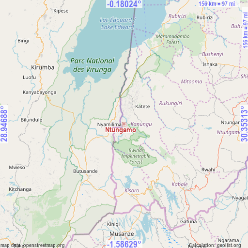
Ntungamo GPS coordinates[2]
0° 52' 59.988" South, 29° 39' 0" East
| Map corner | latitude | longitude |
|---|---|---|
| Upper-left | -0.18024°, | 28.94688° |
| Center: | -0.88333°, | 29.65° |
| Lower-right: | -1.58629°, | 30.35313° |
| Map W x H: | 156.3×156.3 km | = 97.1×97.1mi |
| max Lat: | 3.66088° ⇑96.6% North |
| Ntungamo: | -0.88333° |
| min Lat: | ⇓3.4% South -1.28538° |
| min Long | Ntungamo | max Long |
| 29.65° | 29.65° | 34.95° |
| W 0%⇐ | ⇒100% E |
Elevation
Elevation of Ntungamo is 1170 m = 3839 ft, and this is 89 m = 292 ft below average elevation for this country.
| Max E: |
4129 m = 13547 ft | 54.8% |
| Avg. | 1259 m = 4131 ft | |
| Ntungamo | 1170 m = 3839 ft | |
Min E: |
622 m = 2041 ft | 45.2% |
See also: Uganda elevation on elevation.city.
Geographical zone
Ntungamo is located in South Torrid zone (between Equator and Tropic of Capricorn). Distance of Equator is 98.2 km =61 mi to North.| Distance of | km | miles | from Ntungamo |
|---|---|---|---|
| Equator | 98.2 | 61 | to North |
| Tropic Capricorn | 2507.7 | 1558.2 | to South |
| Antarctic Circle | 7303 | 4537.9 | to South |
| South Pole | 9908.8 | 6157 | to South |


Nearby cities:
15 places around Ntungamo: (largest is in red/bold)
• Buhweju
93.5 km =58.1 mi,  50°
50°
• Bushenyi
70.9 km =44.1 mi,  57°
57°
• Bwizibwera
113.5 km =70.5 mi,  73°
73°
• Kabale
55.5 km =34.5 mi,  137°
137°
• Kanungu
17.6 km =10.9 mi,  117°
117°
• Kibingo
91.9 km =57.1 mi, 71°
• Kihihi
35.3 km =21.9 mi,  8°
8°
• Kisoro
44.9 km =27.9 mi,  175°
175°
• Mitoma
51.7 km =32.1 mi, 64°
• Nsika
104.7 km =65.1 mi, 56°
• Ntungamo
68.3 km =42.4 mi,  89°
89°
• Nyachera
85.3 km =53 mi, 91°
• Rubanda
40.3 km =25 mi,  147°
147°
• Rubirizi
84.3 km =52.4 mi,  39°
39°
• Rukungiri
32.8 km =20.4 mi,  81°
81°
Sources, notices
• [Note1] Compared only with cities in Uganda existing in our database
• [Src1] Map data: © OpenStreetMap contributors (CC-BY-SA)
• [Src2] Other city data from geonames.org with taken over terms of usage.
• [Src3] Geographical zone / Annual Mean Temperature by Robert A. Rohde @ Wikipedia
