Mitoma geodata
Mitoma (Western Region) is a seat of a second-order administrative division; located in Uganda in Africa/Kampala (GMT+3) time zone. In our database, there are 80 cities with bigger population. Compared to other cities in Uganda, 92.5% of cities are located further ↑North; 93.2% of cities are located further →East and 90.4% of cities have lower elevation than Mitoma. Note1
Administrative division(s):
- Level 1: Western Region
- Level 2: Mitoma District
- Level 3: Ruhinda
- Level 4: Mutara


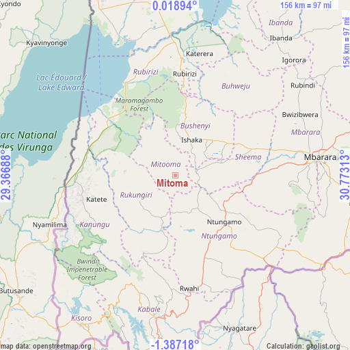
Mitoma GPS coordinates[2]
0° 41' 3.012" South, 30° 4' 12" East
| Map corner | latitude | longitude |
|---|---|---|
| Upper-left | 0.01894°, | 29.36688° |
| Center: | -0.68417°, | 30.07° |
| Lower-right: | -1.38718°, | 30.77313° |
| Map W x H: | 156.3×156.3 km | = 97.1×97.1mi |
| max Lat: | 3.66088° ⇑92.5% North |
| Mitoma: | -0.68417° |
| min Lat: | ⇓7.5% South -1.28538° |
| min Long | Mitoma | max Long |
| 29.65° | 30.07° | 34.95° |
| W 6.8%⇐ | ⇒93.2% E |
Elevation
Elevation of Mitoma is 1596 m = 5236 ft, and this is 337 m = 1106 ft above average elevation for this country.
| Max E: |
4129 m = 13547 ft | 9.6% |
| Mitoma | 1596 m 5236 ft | |
| Avg. | 1259 m = 4131 ft | |
Min E: |
622 m = 2041 ft | 90.4% |
See also: Uganda elevation on elevation.city.
Geographical zone
Mitoma is located in South Torrid zone (between Equator and Tropic of Capricorn). Distance of Equator is 76.1 km =47.3 mi to North.| Distance of | km | miles | from Mitoma |
|---|---|---|---|
| Equator | 76.1 | 47.3 | to North |
| Tropic Capricorn | 2529.8 | 1571.9 | to South |
| Antarctic Circle | 7325.1 | 4551.6 | to South |
| South Pole | 9931 | 6170.8 | to South |


Nearby cities:
15 places around Mitoma: (largest is in red/bold)
• Buhweju
45.1 km =28 mi,  34°
34°
• Bushenyi
20.8 km =12.9 mi,  38°
38°
• Bwizibwera
63 km =39.1 mi,  80°
80°
• Kabale
63.4 km =39.4 mi,  188°
188°
• Kanungu
43.5 km =27 mi,  225°
225°
• Kibingo
41.2 km =25.6 mi, 80°
• Kihihi
43.6 km =27.1 mi,  287°
287°
• Mbarara
64.9 km =40.3 mi, 82°
• Nsika
54.1 km =33.6 mi,  47°
47°
• Ntungamo
30.6 km =19 mi,  135°
135°
• Ntungamo
51.7 km =32.1 mi,  244°
244°
• Nyachera
45.4 km =28.2 mi,  121°
121°
• Rubanda
61.3 km =38.1 mi,  203°
203°
• Rubirizi
43.4 km =27 mi,  9°
9°
• Rukungiri
22.5 km =14 mi,  219°
219°
Sources, notices
• [Note1] Compared only with cities in Uganda existing in our database
• [Src1] Map data: © OpenStreetMap contributors (CC-BY-SA)
• [Src2] Other city data from geonames.org with taken over terms of usage.
• [Src3] Geographical zone / Annual Mean Temperature by Robert A. Rohde @ Wikipedia
