Soroti geodata
Soroti (Eastern Region) is a seat of a second-order administrative division; located in Uganda in Africa/Kampala (GMT+3) time zone. With population of 56,400 people, there are 13 cities with bigger population in this country. Compared to other cities in Uganda, 75.3% of cities are located further ↓South; 78.1% of cities are located further ←West and 64.4% of cities have higher elevation than Soroti. Note1
Administrative division(s):
- Level 1: Eastern Region
- Level 2: Soroti District
- Level 3: Soroti Municipality
- Level 4: Western Division


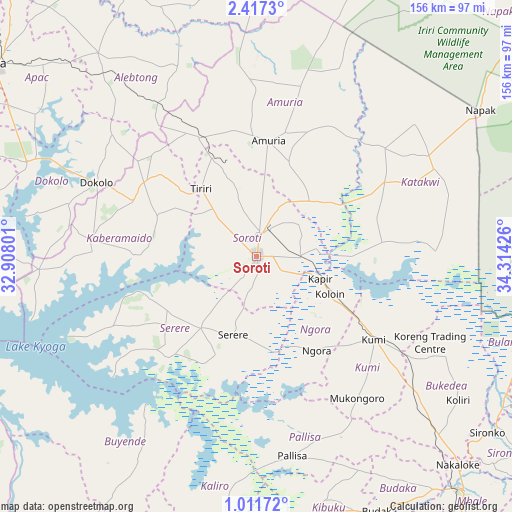
Soroti GPS coordinates[2]
1° 42' 52.704" North, 33° 36' 40.068" East
| Map corner | latitude | longitude |
|---|---|---|
| Upper-left | 2.4173°, | 32.90801° |
| Center: | 1.71464°, | 33.61113° |
| Lower-right: | 1.01172°, | 34.31426° |
| Map W x H: | 156.3×156.3 km | = 97.1×97.1mi |
| max Lat: | 3.66088° ⇑24.7% North |
| Soroti: | 1.71464° |
| min Lat: | ⇓75.3% South -1.28538° |
| min Long | Soroti | max Long |
| 29.65° | 33.61113° | 34.95° |
| W 78.1%⇐ | ⇒21.9% E |
Elevation
Elevation of Soroti is 1131 m = 3711 ft, and this is 128 m = 420 ft below average elevation for this country.
| Max E: |
4129 m = 13547 ft | 64.4% |
| Avg. | 1259 m = 4131 ft | |
| Soroti | 1131 m = 3711 ft | |
Min E: |
622 m = 2041 ft | 35.6% |
See also: Soroti elevation on elevation.city.
Geographical zone
Soroti is located in North Torrid zone (between Equator and Tropic of Cancer). Distance of Equator is 190.7 km =118.5 mi to South.| Distance of | km | miles | from Soroti |
|---|---|---|---|
| North Pole | 9816.4 | 6099.6 | to North |
| Arctic Circle | 7210.5 | 4480.4 | to North |
| Tropic Cancer | 2415.3 | 1500.8 | to North |
| Equator | 190.7 | 118.5 | to South |


Nearby cities:
15 places around Soroti: (largest is in red/bold)
• Alebtong
71 km =44.1 mi,  326°
326°
• Amolatar
86.4 km =53.7 mi,  262°
262°
• Amuria
32.4 km =20.1 mi,  7°
7°
• Budaka
86.4 km =53.7 mi,  156°
156°
• Bukedea
65.9 km =40.9 mi,  132°
132°
• Butebo
67.4 km =41.9 mi,  149°
149°
• Buyende
80.6 km =50.1 mi,  219°
219°
• Dokolo
52.3 km =32.5 mi,  292°
292°
• Kaberamaido
50.3 km =31.3 mi,  273°
273°
• Katakwi
44.1 km =27.4 mi,  63°
63°
• Kibuku
77.5 km =48.2 mi, 164°
• Kumi
45.8 km =28.5 mi, 128°
• Ngora
36.5 km =22.7 mi, 149°
• Pallisa
64.3 km =40 mi,  170°
170°
• Serere
30 km =18.6 mi, 215°
Sources, notices
• [Note1] Compared only with cities in Uganda existing in our database
• [Src1] Map data: © OpenStreetMap contributors (CC-BY-SA)
• [Src2] Other city data from geonames.org with taken over terms of usage.
• [Src3] Geographical zone / Annual Mean Temperature by Robert A. Rohde @ Wikipedia
