Amuria geodata
Amuria (Eastern Region) is a seat of a second-order administrative division; located in Uganda in Africa/Kampala (GMT+3) time zone. In our database, there are 80 cities with bigger population. Compared to other cities in Uganda, 80.8% of cities are located further ↓South; 79.5% of cities are located further ←West and 70.5% of cities have higher elevation than Amuria. Note1
Administrative division(s):
- Level 1: Eastern Region
- Level 2: Amuria District
- Level 3: Amuria County
- Level 4: Asamuk


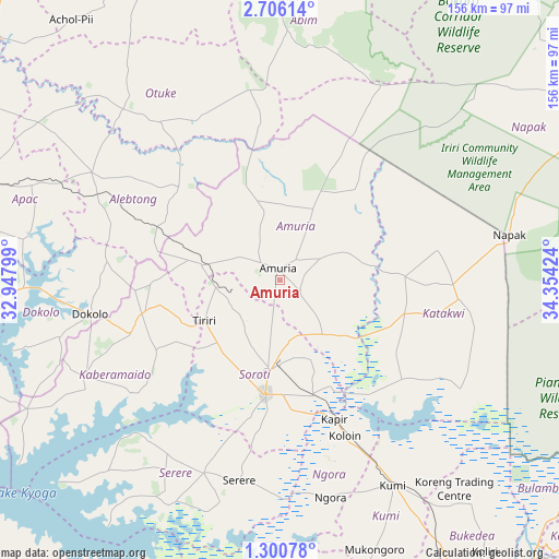
Amuria GPS coordinates[2]
2° 0' 12.996" North, 33° 39' 3.996" East
| Map corner | latitude | longitude |
|---|---|---|
| Upper-left | 2.70614°, | 32.94799° |
| Center: | 2.00361°, | 33.65111° |
| Lower-right: | 1.30078°, | 34.35424° |
| Map W x H: | 156.3×156.3 km | = 97.1×97.1mi |
| max Lat: | 3.66088° ⇑19.2% North |
| Amuria: | 2.00361° |
| min Lat: | ⇓80.8% South -1.28538° |
| min Long | Amuria | max Long |
| 29.65° | 33.65111° | 34.95° |
| W 79.5%⇐ | ⇒20.5% E |
Elevation
Elevation of Amuria is 1123 m = 3684 ft, and this is 136 m = 446 ft below average elevation for this country.
| Max E: |
4129 m = 13547 ft | 70.5% |
| Avg. | 1259 m = 4131 ft | |
| Amuria | 1123 m = 3684 ft | |
Min E: |
622 m = 2041 ft | 29.5% |
See also: Uganda elevation on elevation.city.
Geographical zone
Amuria is located in North Torrid zone (between Equator and Tropic of Cancer). Distance of Equator is 222.8 km =138.4 mi to South.| Distance of | km | miles | from Amuria |
|---|---|---|---|
| North Pole | 9784.3 | 6079.7 | to North |
| Arctic Circle | 7178.4 | 4460.4 | to North |
| Tropic Cancer | 2383.1 | 1480.8 | to North |
| Equator | 222.8 | 138.4 | to South |


Nearby cities:
15 places around Amuria: (largest is in red/bold)
• Abim
77.7 km =48.3 mi,  2°
2°
• Alebtong
51.6 km =32.1 mi,  301°
301°
• Bukedea
88.3 km =54.9 mi,  149°
149°
• Butebo
94.9 km =59 mi,  161°
161°
• Dokolo
53.9 km =33.5 mi,  257°
257°
• Kaberamaido
62.1 km =38.6 mi,  241°
241°
• Katakwi
37.2 km =23.1 mi,  109°
109°
• Kumi
68.2 km =42.4 mi, 152°
• Lira
87.9 km =54.6 mi,  288°
288°
• Napak
72 km =44.7 mi,  67°
67°
• Ngora
65.2 km =40.5 mi,  167°
167°
• Otuke
57.7 km =35.9 mi,  343°
343°
• Pallisa
95.7 km =59.5 mi,  176°
176°
• Serere
60.7 km =37.7 mi,  201°
201°
• Soroti
32.4 km =20.1 mi,  187°
187°
Sources, notices
• [Note1] Compared only with cities in Uganda existing in our database
• [Src1] Map data: © OpenStreetMap contributors (CC-BY-SA)
• [Src2] Other city data from geonames.org with taken over terms of usage.
• [Src3] Geographical zone / Annual Mean Temperature by Robert A. Rohde @ Wikipedia
