Kihihi geodata
Kihihi (Western Region) is a seat of a fourth-order administrative division; located in Uganda in Africa/Kampala (GMT+3) time zone. In our database, there are 80 cities with bigger population. Compared to other cities in Uganda, 88.4% of cities are located further ↑North; 98.6% of cities are located further →East and 97.3% of cities have higher elevation than Kihihi. Note1
Administrative division(s):
- Level 1: Western Region
- Level 2: Kanungu District
- Level 3: Kinkiizi County
- Level 4: Kihiihi


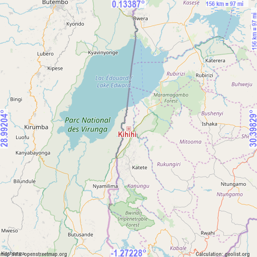
Kihihi GPS coordinates[2]
0° 34' 9.3" South, 29° 41' 42.576" East
| Map corner | latitude | longitude |
|---|---|---|
| Upper-left | 0.13387°, | 28.99204° |
| Center: | -0.56925°, | 29.69516° |
| Lower-right: | -1.27228°, | 30.39829° |
| Map W x H: | 156.3×156.4 km | = 97.1×97.2mi |
| max Lat: | 3.66088° ⇑88.4% North |
| Kihihi: | -0.56925° |
| min Lat: | ⇓11.6% South -1.28538° |
| min Long | Kihihi | max Long |
| 29.65° | 29.69516° | 34.95° |
| W 1.4%⇐ | ⇒98.6% E |
Elevation
Elevation of Kihihi is 943 m = 3094 ft, and this is 316 m = 1037 ft below average elevation for this country.
| Max E: |
4129 m = 13547 ft | 97.3% |
| Avg. | 1259 m = 4131 ft | |
| Kihihi | 943 m = 3094 ft | |
Min E: |
622 m = 2041 ft | 2.7% |
See also: Uganda elevation on elevation.city.
Geographical zone
Kihihi is located in South Torrid zone (between Equator and Tropic of Capricorn). Distance of Equator is 63.3 km =39.3 mi to North.| Distance of | km | miles | from Kihihi |
|---|---|---|---|
| Equator | 63.3 | 39.3 | to North |
| Tropic Capricorn | 2542.6 | 1579.9 | to South |
| Antarctic Circle | 7337.9 | 4559.6 | to South |
| South Pole | 9943.8 | 6178.8 | to South |


Nearby cities:
15 places around Kihihi: (largest is in red/bold)
• Buhweju
71.6 km =44.5 mi,  70°
70°
• Bushenyi
54.7 km =34 mi,  86°
86°
• Kabale
82.3 km =51.1 mi,  156°
156°
• Kanungu
44.4 km =27.6 mi,  166°
166°
• Kibingo
82.6 km =51.3 mi, 94°
• Kilembe
92.4 km =57.4 mi,  22°
22°
• Kisoro
79.6 km =49.5 mi,  180°
180°
• Mitoma
43.6 km =27.1 mi,  107°
107°
• Nsika
85.2 km =52.9 mi, 73°
• Ntungamo
35.3 km =21.9 mi,  188°
188°
• Ntungamo
72.1 km =44.8 mi,  118°
118°
• Nyachera
88.2 km =54.8 mi, 114°
• Rubanda
70.9 km =44.1 mi, 166°
• Rubirizi
57.3 km =35.6 mi,  58°
58°
• Rukungiri
40.8 km =25.4 mi,  137°
137°
Sources, notices
• [Note1] Compared only with cities in Uganda existing in our database
• [Src1] Map data: © OpenStreetMap contributors (CC-BY-SA)
• [Src2] Other city data from geonames.org with taken over terms of usage.
• [Src3] Geographical zone / Annual Mean Temperature by Robert A. Rohde @ Wikipedia
