Kaberamaido geodata
Kaberamaido (Eastern Region) is a seat of a second-order administrative division; located in Uganda in Africa/Kampala (GMT+3) time zone. In our database, there are 80 cities with bigger population. Compared to other cities in Uganda, 76% of cities are located further ↓South; 67.1% of cities are located further ←West and 87% of cities have higher elevation than Kaberamaido. Note1
Administrative division(s):
- Level 1: Eastern Region
- Level 2: Kaberamaido District
- Level 3: Kaberamaido County
- Level 4: Kaberamaido


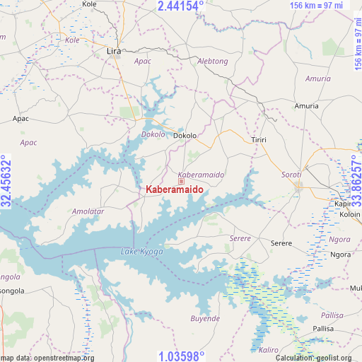
Kaberamaido GPS coordinates[2]
1° 44' 20.004" North, 33° 9' 33.984" East
| Map corner | latitude | longitude |
|---|---|---|
| Upper-left | 2.44154°, | 32.45632° |
| Center: | 1.73889°, | 33.15944° |
| Lower-right: | 1.03598°, | 33.86257° |
| Map W x H: | 156.3×156.3 km | = 97.1×97.1mi |
| max Lat: | 3.66088° ⇑24% North |
| Kaberamaido: | 1.73889° |
| min Lat: | ⇓76% South -1.28538° |
| min Long | Kaberamaido | max Long |
| 29.65° | 33.15944° | 34.95° |
| W 67.1%⇐ | ⇒32.9% E |
Elevation
Elevation of Kaberamaido is 1057 m = 3468 ft, and this is 202 m = 663 ft below average elevation for this country.
| Max E: |
4129 m = 13547 ft | 87% |
| Avg. | 1259 m = 4131 ft | |
| Kaberamaido | 1057 m = 3468 ft | |
Min E: |
622 m = 2041 ft | 13% |
See also: Uganda elevation on elevation.city.
Geographical zone
Kaberamaido is located in North Torrid zone (between Equator and Tropic of Cancer). Distance of Equator is 193.3 km =120.1 mi to South.| Distance of | km | miles | from Kaberamaido |
|---|---|---|---|
| North Pole | 9813.7 | 6097.9 | to North |
| Arctic Circle | 7207.8 | 4478.7 | to North |
| Tropic Cancer | 2412.6 | 1499.1 | to North |
| Equator | 193.3 | 120.1 | to South |


Nearby cities:
15 places around Kaberamaido: (largest is in red/bold)
• Alebtong
57.2 km =35.5 mi,  10°
10°
• Amolatar
38.1 km =23.7 mi,  248°
248°
• Amuria
62.1 km =38.6 mi,  61°
61°
• Apac
73.8 km =45.9 mi,  290°
290°
• Buyende
65.3 km =40.6 mi,  180°
180°
• Dokolo
17.8 km =11.1 mi, 6°
• Kamuli
88.1 km =54.7 mi, 182°
• Katakwi
91.2 km =56.7 mi,  79°
79°
• Kole
83.7 km =52 mi,  331°
331°
• Lira
63.7 km =39.6 mi, 333°
• Nakasongola
91.6 km =56.9 mi,  238°
238°
• Ngora
76.7 km =47.7 mi,  116°
116°
• Pallisa
90 km =55.9 mi,  137°
137°
• Serere
42.7 km =26.5 mi,  129°
129°
• Soroti
50.3 km =31.3 mi,  93°
93°
Sources, notices
• [Note1] Compared only with cities in Uganda existing in our database
• [Src1] Map data: © OpenStreetMap contributors (CC-BY-SA)
• [Src2] Other city data from geonames.org with taken over terms of usage.
• [Src3] Geographical zone / Annual Mean Temperature by Robert A. Rohde @ Wikipedia
