Amolatar geodata
Amolatar (Northern Region) is a seat of a second-order administrative division; located in Uganda in Africa/Kampala (GMT+3) time zone. In our database, there are 80 cities with bigger population. Compared to other cities in Uganda, 72.6% of cities are located further ↓South; 61% of cities are located further ←West and 90.4% of cities have higher elevation than Amolatar. Note1
Administrative division(s):
- Level 1: Northern Region
- Level 2: Amolatar District
- Level 3: Kioga County
- Level 4: Agwingiri


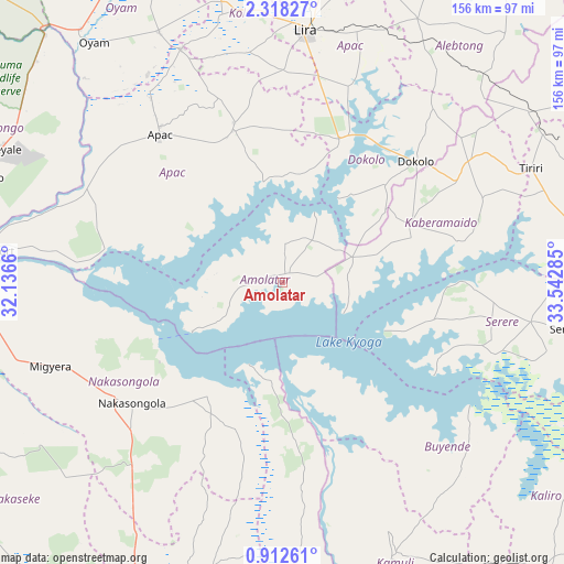
Amolatar GPS coordinates[2]
1° 36' 56.016" North, 32° 50' 22.992" East
| Map corner | latitude | longitude |
|---|---|---|
| Upper-left | 2.31827°, | 32.1366° |
| Center: | 1.61556°, | 32.83972° |
| Lower-right: | 0.91261°, | 33.54285° |
| Map W x H: | 156.3×156.3 km | = 97.1×97.1mi |
| max Lat: | 3.66088° ⇑27.4% North |
| Amolatar: | 1.61556° |
| min Lat: | ⇓72.6% South -1.28538° |
| min Long | Amolatar | max Long |
| 29.65° | 32.83972° | 34.95° |
| W 61%⇐ | ⇒39% E |
Elevation
Elevation of Amolatar is 1041 m = 3415 ft, and this is 218 m = 715 ft below average elevation for this country.
| Max E: |
4129 m = 13547 ft | 90.4% |
| Avg. | 1259 m = 4131 ft | |
| Amolatar | 1041 m = 3415 ft | |
Min E: |
622 m = 2041 ft | 9.6% |
See also: Uganda elevation on elevation.city.
Geographical zone
Amolatar is located in North Torrid zone (between Equator and Tropic of Cancer). Distance of Equator is 179.6 km =111.6 mi to South.| Distance of | km | miles | from Amolatar |
|---|---|---|---|
| North Pole | 9827.4 | 6106.5 | to North |
| Arctic Circle | 7221.5 | 4487.2 | to North |
| Tropic Cancer | 2426.3 | 1507.6 | to North |
| Equator | 179.6 | 111.6 | to South |


Nearby cities:
15 places around Amolatar: (largest is in red/bold)
• Alebtong
83.8 km =52.1 mi,  33°
33°
• Apac
52.2 km =32.4 mi,  320°
320°
• Buyende
62.4 km =38.8 mi,  145°
145°
• Dokolo
49 km =30.4 mi,  50°
50°
• Kaberamaido
38.1 km =23.7 mi,  68°
68°
• Kamuli
80.6 km =50.1 mi,  157°
157°
• Kiryandongo
91.1 km =56.6 mi,  288°
288°
• Kole
87.3 km =54.2 mi,  357°
357°
• Lira
70.8 km =44 mi,  5°
5°
• Luwero
94.5 km =58.7 mi,  205°
205°
• Masindi Port
84.2 km =52.3 mi,  276°
276°
• Nakasongola
54.6 km =33.9 mi,  231°
231°
• Oyam
85.4 km =53.1 mi, 323°
• Serere
69.7 km =43.3 mi,  101°
101°
• Soroti
86.4 km =53.7 mi,  82°
82°
Sources, notices
• [Note1] Compared only with cities in Uganda existing in our database
• [Src1] Map data: © OpenStreetMap contributors (CC-BY-SA)
• [Src2] Other city data from geonames.org with taken over terms of usage.
• [Src3] Geographical zone / Annual Mean Temperature by Robert A. Rohde @ Wikipedia
