Amudat geodata
Amudat (Northern Region) is a seat of a second-order administrative division; located in Uganda in Africa/Kampala (GMT+3) time zone. With population of 1,873 people, there are 77 cities with bigger population in this country. Compared to other cities in Uganda, 79.5% of cities are located further ↓South; 100% of cities are located further ←West and 65.1% of cities have lower elevation than Amudat. Note1
Administrative division(s):
- Level 1: Northern Region
- Level 2: Amudat District
- Level 3: Pokot
- Level 4: Amudat Town Council


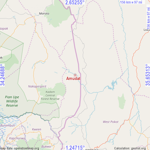
Amudat GPS coordinates[2]
1° 57' 0" North, 34° 57' 0" East
| Map corner | latitude | longitude |
|---|---|---|
| Upper-left | 2.65255°, | 34.24688° |
| Center: | 1.95°, | 34.95° |
| Lower-right: | 1.24715°, | 35.65313° |
| Map W x H: | 156.3×156.3 km | = 97.1×97.1mi |
| max Lat: | 3.66088° ⇑20.5% North |
| Amudat: | 1.95° |
| min Lat: | ⇓79.5% South -1.28538° |
| min Long | Amudat | max Long |
| 29.65° | 34.95° | 34.95° |
| W 100%⇐ | ⇒0% E |
Elevation
Elevation of Amudat is 1244 m = 4081 ft, and this is 15 m = 49 ft below average elevation for this country.
| Max E: |
4129 m = 13547 ft | 34.9% |
| Avg. | 1259 m = 4131 ft | |
| Amudat | 1244 m = 4081 ft | |
Min E: |
622 m = 2041 ft | 65.1% |
See also: Uganda elevation on elevation.city.
Geographical zone
Amudat is located in North Torrid zone (between Equator and Tropic of Cancer). Distance of Equator is 216.8 km =134.7 mi to South.| Distance of | km | miles | from Amudat |
|---|---|---|---|
| North Pole | 9790.2 | 6083.3 | to North |
| Arctic Circle | 7184.4 | 4464.2 | to North |
| Tropic Cancer | 2389.1 | 1484.5 | to North |
| Equator | 216.8 | 134.7 | to South |


Nearby cities:
15 places around Amudat: (largest is in red/bold)
• Binyin
75.2 km =46.7 mi,  217°
217°
• Bududa
125 km =77.7 mi,  213°
213°
• Bukedea
122.3 km =76 mi,  234°
234°
• Bukwa
79.8 km =49.6 mi,  195°
195°
• Bulambuli
107.5 km =66.8 mi, 215°
• Bupoto
133.4 km =82.9 mi, 209°
• Kapchorwa
82.5 km =51.3 mi, 222°
• Katakwi
109.5 km =68 mi,  266°
266°
• Kumi
125.1 km =77.7 mi,  244°
244°
• Manafwa
125.6 km =78 mi, 210°
• Mbale
129.4 km =80.4 mi, 221°
• Moroto
72.2 km =44.9 mi,  334°
334°
• Nakapiripirit
18.9 km =11.7 mi,  258°
258°
• Napak
84.7 km =52.6 mi,  293°
293°
• Sironko
111.7 km =69.4 mi, 224°
Sources, notices
• [Note1] Compared only with cities in Uganda existing in our database
• [Src1] Map data: © OpenStreetMap contributors (CC-BY-SA)
• [Src2] Other city data from geonames.org with taken over terms of usage.
• [Src3] Geographical zone / Annual Mean Temperature by Robert A. Rohde @ Wikipedia
