Moroto geodata
Moroto (Northern Region) is a seat of a second-order administrative division; located in Uganda in Africa/Kampala (GMT+3) time zone. With population of 10,300 people, there are 64 cities with bigger population in this country. Compared to other cities in Uganda, 88.4% of cities are located further ↓South; 97.9% of cities are located further ←West and 80.1% of cities have lower elevation than Moroto. Note1
Administrative division(s):
- Level 1: Northern Region
- Level 2: Moroto District
- Level 3: Moroto Municipality
- Level 4: Northern Division


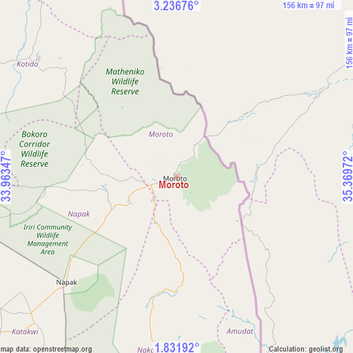
Moroto GPS coordinates[2]
2° 32' 4.308" North, 34° 39' 59.724" East
| Map corner | latitude | longitude |
|---|---|---|
| Upper-left | 3.23676°, | 33.96347° |
| Center: | 2.53453°, | 34.66659° |
| Lower-right: | 1.83192°, | 35.36972° |
| Map W x H: | 156.2×156.2 km | = 97.1×97.1mi |
| max Lat: | 3.66088° ⇑11.6% North |
| Moroto: | 2.53453° |
| min Lat: | ⇓88.4% South -1.28538° |
| min Long | Moroto | max Long |
| 29.65° | 34.66659° | 34.95° |
| W 97.9%⇐ | ⇒2.1% E |
Elevation
Elevation of Moroto is 1393 m = 4570 ft, and this is 134 m = 440 ft above average elevation for this country.
| Max E: |
4129 m = 13547 ft | 19.9% |
| Moroto | 1393 m 4570 ft | |
| Avg. | 1259 m = 4131 ft | |
Min E: |
622 m = 2041 ft | 80.1% |
See also: Uganda elevation on elevation.city.
Geographical zone
Moroto is located in North Torrid zone (between Equator and Tropic of Cancer). Distance of Equator is 281.8 km =175.1 mi to South.| Distance of | km | miles | from Moroto |
|---|---|---|---|
| North Pole | 9725.2 | 6043 | to North |
| Arctic Circle | 7119.4 | 4423.8 | to North |
| Tropic Cancer | 2324.1 | 1444.1 | to North |
| Equator | 281.8 | 175.1 | to South |


Nearby cities:
15 places around Moroto: (largest is in red/bold)
• Abim
111.6 km =69.3 mi,  279°
279°
• Amudat
72.2 km =44.9 mi,  154°
154°
• Amuria
127.3 km =79.1 mi,  242°
242°
• Binyin
125.2 km =77.8 mi,  186°
186°
• Bukedea
151.7 km =94.3 mi,  206°
206°
• Bukwa
142.1 km =88.3 mi,  176°
176°
• Kaabong
120.2 km =74.7 mi,  331°
331°
• Kapchorwa
128.3 km =79.7 mi, 190°
• Katakwi
105.7 km =65.7 mi,  227°
227°
• Kotido
77.3 km =48 mi,  309°
309°
• Kumi
144.4 km =89.7 mi, 214°
• Nakapiripirit
69.9 km =43.4 mi,  169°
169°
• Napak
56 km =34.8 mi, 235°
• Otuke
129.6 km =80.5 mi,  268°
268°
• Soroti
148.5 km =92.3 mi, 232°
Sources, notices
• [Note1] Compared only with cities in Uganda existing in our database
• [Src1] Map data: © OpenStreetMap contributors (CC-BY-SA)
• [Src2] Other city data from geonames.org with taken over terms of usage.
• [Src3] Geographical zone / Annual Mean Temperature by Robert A. Rohde @ Wikipedia
