Napak geodata
Napak (Northern Region) is a seat of a second-order administrative division; located in Uganda in Africa/Kampala (GMT+3) time zone. In our database, there are 80 cities with bigger population. Compared to other cities in Uganda, 84.2% of cities are located further ↓South; 93.2% of cities are located further ←West and 56.2% of cities have higher elevation than Napak. Note1
Administrative division(s):
- Level 1: Northern Region
- Level 2: Napak District
- Level 3: Bokora County
- Level 4: Lorengecora


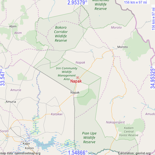
Napak GPS coordinates[2]
2° 15' 5.004" North, 34° 15' 0.432" East
| Map corner | latitude | longitude |
|---|---|---|
| Upper-left | 2.95379°, | 33.547° |
| Center: | 2.25139°, | 34.25012° |
| Lower-right: | 1.54866°, | 34.95325° |
| Map W x H: | 156.2×156.2 km | = 97.1×97.1mi |
| max Lat: | 3.66088° ⇑15.8% North |
| Napak: | 2.25139° |
| min Lat: | ⇓84.2% South -1.28538° |
| min Long | Napak | max Long |
| 29.65° | 34.25012° | 34.95° |
| W 93.2%⇐ | ⇒6.8% E |
Elevation
Elevation of Napak is 1162 m = 3812 ft, and this is 97 m = 318 ft below average elevation for this country.
| Max E: |
4129 m = 13547 ft | 56.2% |
| Avg. | 1259 m = 4131 ft | |
| Napak | 1162 m = 3812 ft | |
Min E: |
622 m = 2041 ft | 43.8% |
See also: Uganda elevation on elevation.city.
Geographical zone
Napak is located in North Torrid zone (between Equator and Tropic of Cancer). Distance of Equator is 250.3 km =155.5 mi to South.| Distance of | km | miles | from Napak |
|---|---|---|---|
| North Pole | 9756.7 | 6062.5 | to North |
| Arctic Circle | 7150.8 | 4443.3 | to North |
| Tropic Cancer | 2355.6 | 1463.7 | to North |
| Equator | 250.3 | 155.5 | to South |


Nearby cities:
15 places around Napak: (largest is in red/bold)
• Abim
81.1 km =50.4 mi,  308°
308°
• Alebtong
110.6 km =68.7 mi,  269°
269°
• Amudat
84.7 km =52.6 mi,  113°
113°
• Amuria
72 km =44.7 mi,  247°
247°
• Binyin
98 km =60.9 mi,  161°
161°
• Bukedea
106.2 km =66 mi,  192°
192°
• Kapchorwa
97.1 km =60.3 mi,  166°
166°
• Katakwi
51 km =31.7 mi,  218°
218°
• Kotido
82.1 km =51 mi,  350°
350°
• Kumi
94.6 km =58.8 mi,  201°
201°
• Moroto
56 km =34.8 mi,  55°
55°
• Nakapiripirit
70 km =43.5 mi,  122°
122°
• Ngora
105.2 km =65.4 mi,  209°
209°
• Otuke
87.7 km =54.5 mi,  288°
288°
• Soroti
92.8 km =57.7 mi,  229°
229°
Sources, notices
• [Note1] Compared only with cities in Uganda existing in our database
• [Src1] Map data: © OpenStreetMap contributors (CC-BY-SA)
• [Src2] Other city data from geonames.org with taken over terms of usage.
• [Src3] Geographical zone / Annual Mean Temperature by Robert A. Rohde @ Wikipedia
