Clayton geodata
Clayton (Alabama) is a seat of a second-order administrative division; located in United States in America/Chicago (GMT-5) time zone. With population of 2,925 people, there are 9761 cities with bigger population in this country. Compared to other cities in United States, 88.8% of cities are located further ↑North; 54.7% of cities are located further ←West and 53.9% of cities have higher elevation than Clayton. Note1


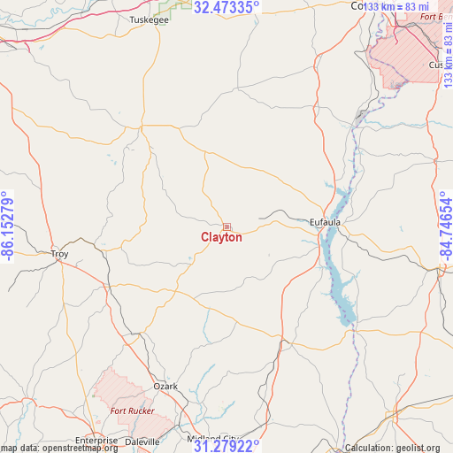
Clayton GPS coordinates[2]
31° 52' 41.592" North, 85° 26' 58.776" West
| Map corner | latitude | longitude |
|---|---|---|
| Upper-left | 32.47335°, | -86.15279° |
| Center: | 31.87822°, | -85.44966° |
| Lower-right: | 31.27922°, | -84.74654° |
| Map W x H: | 132.8×132.8 km | = 82.5×82.5mi |
| max Lat: | 71.29058° ⇑88.8% North |
| Clayton: | 31.87822° |
| min Lat: | ⇓11.2% South 19.06759° |
| min Long | Clayton | max Long |
| -171.73463° | -85.44966° | -66.98998° |
| W 54.7%⇐ | ⇒45.3% E |
Elevation
Elevation of Clayton is 184 m = 604 ft, and this is 110.8 m = 364 ft below average elevation for this country.
| Max E: |
3189 m = 10463 ft | 53.9% |
| Avg. | 294.8 m = 967 ft | |
| Clayton | 184 m = 604 ft | |
Min E: |
-60 m = -197 ft | 46.1% |
See also: United States elevation on elevation.city.
Geographical zone
Clayton is located in North temperate zone (between Tropic of Cancer and the Arctic Circle). Distance of this Northern Tropic circle is 938.6 km =583.2 mi to South.| Distance of | km | miles | from Clayton |
|---|---|---|---|
| North Pole | 6462.5 | 4015.6 | to North |
| Arctic Circle | 3856.6 | 2396.4 | to North |
| Tropic Cancer | 938.6 | 583.2 | to South |
| Equator | 3544.5 | 2202.4 | to South |


Nearby cities:
15 places around Clayton: (largest is in red/bold)
• Abbeville
38.9 km =24.2 mi,  151°
151°
• Ariton
40 km =24.9 mi,  219°
219°
• Brundidge
38.8 km =24.1 mi,  243°
243°
• Clio
24.2 km =15 mi, 218°
• Eufaula
28.8 km =17.9 mi,  87°
87°
• Fort Gaines
48.2 km =30 mi,  128°
128°
• Georgetown
32.3 km =20.1 mi, 88°
• Headland
59.5 km =37 mi,  170°
170°
• Hurtsboro
40.5 km =25.2 mi,  4°
4°
• Inverness
31.8 km =19.8 mi,  298°
298°
• Newton
62.2 km =38.6 mi,  193°
193°
• Newville
51.8 km =32.2 mi, 168°
• Ozark
50 km =31.1 mi,  201°
201°
• Troy
49.7 km =30.9 mi,  261°
261°
• Union Springs
38.7 km =24 mi,  319°
319°
Sources, notices
• [Note1] Compared only with cities in United States existing in our database
• [Src1] Map data: © OpenStreetMap contributors (CC-BY-SA)
• [Src2] Other city data from geonames.org with taken over terms of usage.
• [Src3] Geographical zone / Annual Mean Temperature by Robert A. Rohde @ Wikipedia
