Inverness geodata
Inverness (Alabama) is a populated place; located in United States in America/Chicago (GMT-5) time zone. With population of 1,621 people, there are 13214 cities with bigger population in this country. Compared to other cities in United States, 88.5% of cities are located further ↑North; 53.6% of cities are located further ←West and 63.5% of cities have higher elevation than Inverness. Note1


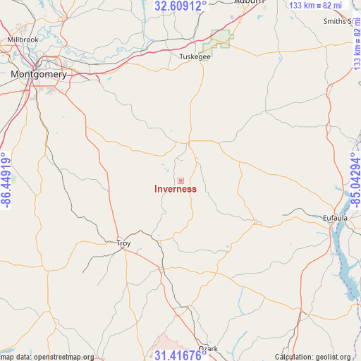
Inverness GPS coordinates[2]
32° 0' 53.568" North, 85° 44' 45.816" West
| Map corner | latitude | longitude |
|---|---|---|
| Upper-left | 32.60912°, | -86.44919° |
| Center: | 32.01488°, | -85.74606° |
| Lower-right: | 31.41676°, | -85.04294° |
| Map W x H: | 132.6×132.6 km | = 82.4×82.4mi |
| max Lat: | 71.29058° ⇑88.5% North |
| Inverness: | 32.01488° |
| min Lat: | ⇓11.5% South 19.06759° |
| min Long | Inverness | max Long |
| -171.73463° | -85.74606° | -66.98998° |
| W 53.6%⇐ | ⇒46.4% E |
Elevation
Elevation of Inverness is 136 m = 446 ft, and this is 158.8 m = 521 ft below average elevation for this country.
| Max E: |
3189 m = 10463 ft | 63.5% |
| Avg. | 294.8 m = 967 ft | |
| Inverness | 136 m = 446 ft | |
Min E: |
-60 m = -197 ft | 36.5% |
See also: United States elevation on elevation.city.
Geographical zone
Inverness is located in North temperate zone (between Tropic of Cancer and the Arctic Circle). Distance of this Northern Tropic circle is 953.8 km =592.7 mi to South.| Distance of | km | miles | from Inverness |
|---|---|---|---|
| North Pole | 6447.3 | 4006.2 | to North |
| Arctic Circle | 3841.5 | 2387 | to North |
| Tropic Cancer | 953.8 | 592.7 | to South |
| Equator | 3559.7 | 2211.9 | to South |


Nearby cities:
15 places around Inverness: (largest is in red/bold)
• Ariton
46.2 km =28.7 mi,  176°
176°
• Brundidge
33.4 km =20.8 mi,  191°
191°
• Clayton
31.8 km =19.8 mi,  118°
118°
• Clio
36.4 km =22.6 mi,  159°
159°
• Emerald Mountain
58.2 km =36.2 mi,  325°
325°
• Eufaula
58.3 km =36.2 mi,  103°
103°
• Hurtsboro
40 km =24.9 mi,  50°
50°
• Joquin
46.9 km =29.1 mi,  237°
237°
• Matthews
36.9 km =22.9 mi,  318°
318°
• Pike Road
45 km =28 mi,  311°
311°
• Pisgah
35.2 km =21.9 mi,  266°
266°
• Taylor
46.2 km =28.7 mi,  264°
264°
• Troy
31.2 km =19.4 mi,  222°
222°
• Tuskegee
45.8 km =28.5 mi,  6°
6°
• Union Springs
14.7 km =9.1 mi, 11°
Sources, notices
• [Note1] Compared only with cities in United States existing in our database
• [Src1] Map data: © OpenStreetMap contributors (CC-BY-SA)
• [Src2] Other city data from geonames.org with taken over terms of usage.
• [Src3] Geographical zone / Annual Mean Temperature by Robert A. Rohde @ Wikipedia
