Troy geodata
Troy (Alabama) is a seat of a second-order administrative division; located in United States in America/Chicago (GMT-5) time zone. With population of 18,853 people, there are 2675 cities with bigger population in this country. Compared to other cities in United States, 89% of cities are located further ↑North; 53% of cities are located further ←West and 57.3% of cities have higher elevation than Troy. Note1


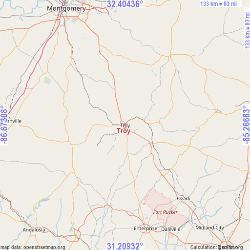
Troy GPS coordinates[2]
31° 48' 31.572" North, 85° 58' 11.82" West
| Map corner | latitude | longitude |
|---|---|---|
| Upper-left | 32.40436°, | -86.67308° |
| Center: | 31.80877°, | -85.96995° |
| Lower-right: | 31.20932°, | -85.26683° |
| Map W x H: | 132.9×132.9 km | = 82.6×82.6mi |
| max Lat: | 71.29058° ⇑89% North |
| Troy: | 31.80877° |
| min Lat: | ⇓11% South 19.06759° |
| min Long | Troy | max Long |
| -171.73463° | -85.96995° | -66.98998° |
| W 53%⇐ | ⇒47% E |
Elevation
Elevation of Troy is 169 m = 554 ft, and this is 125.8 m = 413 ft below average elevation for this country.
| Max E: |
3189 m = 10463 ft | 57.3% |
| Avg. | 294.8 m = 967 ft | |
| Troy | 169 m = 554 ft | |
Min E: |
-60 m = -197 ft | 42.7% |
See also: United States elevation on elevation.city.
Geographical zone
Troy is located in North temperate zone (between Tropic of Cancer and the Arctic Circle). Distance of this Northern Tropic circle is 930.9 km =578.4 mi to South.| Distance of | km | miles | from Troy |
|---|---|---|---|
| North Pole | 6470.3 | 4020.5 | to North |
| Arctic Circle | 3864.4 | 2401.2 | to North |
| Tropic Cancer | 930.9 | 578.4 | to South |
| Equator | 3536.8 | 2197.7 | to South |


Nearby cities:
15 places around Troy: (largest is in red/bold)
• Ariton
33.2 km =20.6 mi,  134°
134°
• Brantley
37 km =23 mi,  227°
227°
• Brundidge
17.6 km =10.9 mi,  124°
124°
• Clayton
49.7 km =30.9 mi,  81°
81°
• Clio
35.8 km =22.2 mi,  108°
108°
• Elba
44.8 km =27.8 mi,  191°
191°
• Inverness
31.2 km =19.4 mi,  42°
42°
• Joquin
18.5 km =11.5 mi,  262°
262°
• Luverne
29.6 km =18.4 mi,  249°
249°
• Matthews
50.9 km =31.6 mi,  356°
356°
• New Brockton
47.2 km =29.3 mi,  175°
175°
• Ozark
49.8 km =30.9 mi,  141°
141°
• Pisgah
25.2 km =15.7 mi,  326°
326°
• Taylor
31 km =19.3 mi,  306°
306°
• Union Springs
44.4 km =27.6 mi,  32°
32°
Sources, notices
• [Note1] Compared only with cities in United States existing in our database
• [Src1] Map data: © OpenStreetMap contributors (CC-BY-SA)
• [Src2] Other city data from geonames.org with taken over terms of usage.
• [Src3] Geographical zone / Annual Mean Temperature by Robert A. Rohde @ Wikipedia
