Union Springs geodata
Union Springs (Alabama) is a seat of a second-order administrative division; located in United States in America/Chicago (GMT-5) time zone. With population of 3,919 people, there are 8306 cities with bigger population in this country. Compared to other cities in United States, 88.2% of cities are located further ↑North; 53.7% of cities are located further ←West and 58.8% of cities have higher elevation than Union Springs. Note1


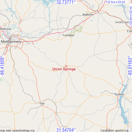
Union Springs GPS coordinates[2]
32° 8' 39.552" North, 85° 42' 53.82" West
| Map corner | latitude | longitude |
|---|---|---|
| Upper-left | 32.73771°, | -86.41808° |
| Center: | 32.14432°, | -85.71495° |
| Lower-right: | 31.54704°, | -85.01183° |
| Map W x H: | 132.4×132.4 km | = 82.3×82.3mi |
| max Lat: | 71.29058° ⇑88.2% North |
| Union Springs: | 32.14432° |
| min Lat: | ⇓11.8% South 19.06759° |
| min Long | Union Springs | max Long |
| -171.73463° | -85.71495° | -66.98998° |
| W 53.7%⇐ | ⇒46.3% E |
Elevation
Elevation of Union Springs is 161 m = 528 ft, and this is 133.8 m = 439 ft below average elevation for this country.
| Max E: |
3189 m = 10463 ft | 58.8% |
| Avg. | 294.8 m = 967 ft | |
| Union Springs | 161 m = 528 ft | |
Min E: |
-60 m = -197 ft | 41.2% |
See also: United States elevation on elevation.city.
Geographical zone
Union Springs is located in North temperate zone (between Tropic of Cancer and the Arctic Circle). Distance of this Northern Tropic circle is 968.2 km =601.6 mi to South.| Distance of | km | miles | from Union Springs |
|---|---|---|---|
| North Pole | 6432.9 | 3997.2 | to North |
| Arctic Circle | 3827.1 | 2378 | to North |
| Tropic Cancer | 968.2 | 601.6 | to South |
| Equator | 3574.1 | 2220.8 | to South |


Nearby cities:
15 places around Union Springs: (largest is in red/bold)
• Brundidge
48.1 km =29.9 mi,  191°
191°
• Clayton
38.7 km =24 mi,  139°
139°
• Clio
49.4 km =30.7 mi,  168°
168°
• Emerald Mountain
49.1 km =30.5 mi,  313°
313°
• Hurtsboro
30.1 km =18.7 mi,  68°
68°
• Inverness
14.7 km =9.1 mi, 191°
• Matthews
30.3 km =18.8 mi,  296°
296°
• Notasulga
46.5 km =28.9 mi,  4°
4°
• Pike Road
39.7 km =24.7 mi,  293°
293°
• Pisgah
41.4 km =25.7 mi,  246°
246°
• Reeltown
51.8 km =32.2 mi,  350°
350°
• Tallassee
46.7 km =29 mi,  338°
338°
• Taylor
52.3 km =32.5 mi, 248°
• Troy
44.4 km =27.6 mi,  212°
212°
• Tuskegee
31.2 km =19.4 mi, 4°
Sources, notices
• [Note1] Compared only with cities in United States existing in our database
• [Src1] Map data: © OpenStreetMap contributors (CC-BY-SA)
• [Src2] Other city data from geonames.org with taken over terms of usage.
• [Src3] Geographical zone / Annual Mean Temperature by Robert A. Rohde @ Wikipedia
