Brundidge geodata
Brundidge (Alabama) is a populated place; located in United States in America/Chicago (GMT-5) time zone. With population of 1,989 people, there are 11970 cities with bigger population in this country. Compared to other cities in United States, 89.1% of cities are located further ↑North; 53.4% of cities are located further ←West and 60.9% of cities have higher elevation than Brundidge. Note1


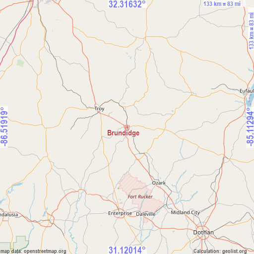
Brundidge GPS coordinates[2]
31° 43' 12.576" North, 85° 48' 57.816" West
| Map corner | latitude | longitude |
|---|---|---|
| Upper-left | 32.31632°, | -86.51919° |
| Center: | 31.72016°, | -85.81606° |
| Lower-right: | 31.12014°, | -85.11294° |
| Map W x H: | 133×133 km | = 82.6×82.6mi |
| max Lat: | 71.29058° ⇑89.1% North |
| Brundidge: | 31.72016° |
| min Lat: | ⇓10.9% South 19.06759° |
| min Long | Brundidge | max Long |
| -171.73463° | -85.81606° | -66.98998° |
| W 53.4%⇐ | ⇒46.6% E |
Elevation
Elevation of Brundidge is 150 m = 492 ft, and this is 144.8 m = 475 ft below average elevation for this country.
| Max E: |
3189 m = 10463 ft | 60.9% |
| Avg. | 294.8 m = 967 ft | |
| Brundidge | 150 m = 492 ft | |
Min E: |
-60 m = -197 ft | 39.1% |
See also: United States elevation on elevation.city.
Geographical zone
Brundidge is located in North temperate zone (between Tropic of Cancer and the Arctic Circle). Distance of this Northern Tropic circle is 921 km =572.3 mi to South.| Distance of | km | miles | from Brundidge |
|---|---|---|---|
| North Pole | 6480.1 | 4026.5 | to North |
| Arctic Circle | 3874.2 | 2407.3 | to North |
| Tropic Cancer | 921 | 572.3 | to South |
| Equator | 3527 | 2191.6 | to South |


Nearby cities:
15 places around Brundidge: (largest is in red/bold)
• Ariton
16.2 km =10.1 mi,  145°
145°
• Brantley
44.5 km =27.7 mi,  249°
249°
• Clayton
38.8 km =24.1 mi,  63°
63°
• Clio
19.5 km =12.1 mi,  93°
93°
• Daleville
46.6 km =29 mi,  167°
167°
• Elba
41.5 km =25.8 mi,  215°
215°
• Enterprise
45.2 km =28.1 mi,  184°
184°
• Fort Rucker
43 km =26.7 mi, 167°
• Inverness
33.4 km =20.8 mi,  11°
11°
• Joquin
33.7 km =20.9 mi,  282°
282°
• Luverne
42.4 km =26.3 mi,  269°
269°
• New Brockton
38.7 km =24 mi,  196°
196°
• Ozark
33.5 km =20.8 mi, 150°
• Pisgah
42 km =26.1 mi,  317°
317°
• Troy
17.6 km =10.9 mi,  304°
304°
Sources, notices
• [Note1] Compared only with cities in United States existing in our database
• [Src1] Map data: © OpenStreetMap contributors (CC-BY-SA)
• [Src2] Other city data from geonames.org with taken over terms of usage.
• [Src3] Geographical zone / Annual Mean Temperature by Robert A. Rohde @ Wikipedia
