Auburn geodata
Auburn (Alabama) is a populated place; located in United States in America/Chicago (GMT-5) time zone. With population of 62,059 people, there are 709 cities with bigger population in this country. Compared to other cities in United States, 86.7% of cities are located further ↑North; 54.7% of cities are located further ←West and 55.4% of cities have lower elevation than Auburn. Note1


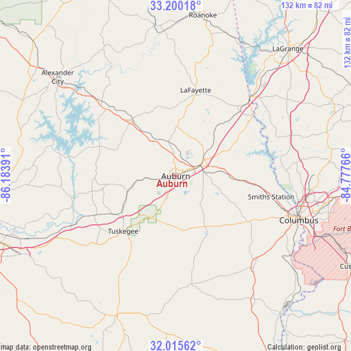
Auburn GPS coordinates[2]
32° 36' 35.496" North, 85° 28' 50.808" West
| Map corner | latitude | longitude |
|---|---|---|
| Upper-left | 33.20018°, | -86.18391° |
| Center: | 32.60986°, | -85.48078° |
| Lower-right: | 32.01562°, | -84.77766° |
| Map W x H: | 131.7×131.7 km | = 81.8×81.8mi |
| max Lat: | 71.29058° ⇑86.7% North |
| Auburn: | 32.60986° |
| min Lat: | ⇓13.3% South 19.06759° |
| min Long | Auburn | max Long |
| -171.73463° | -85.48078° | -66.98998° |
| W 54.7%⇐ | ⇒45.3% E |
Elevation
Elevation of Auburn is 220 m = 722 ft, and this is 74.8 m = 245 ft below average elevation for this country.
| Max E: |
3189 m = 10463 ft | 44.6% |
| Avg. | 294.8 m = 967 ft | |
| Auburn | 220 m = 722 ft | |
Min E: |
-60 m = -197 ft | 55.4% |
See also: Auburn elevation on elevation.city.
Geographical zone
Auburn is located in North temperate zone (between Tropic of Cancer and the Arctic Circle). Distance of this Northern Tropic circle is 1020 km =633.8 mi to South.| Distance of | km | miles | from Auburn |
|---|---|---|---|
| North Pole | 6381.2 | 3965.1 | to North |
| Arctic Circle | 3775.3 | 2345.9 | to North |
| Tropic Cancer | 1020 | 633.8 | to South |
| Equator | 3625.9 | 2253 | to South |


Nearby cities:
15 places around Auburn: (largest is in red/bold)
• Camp Hill
26.7 km =16.6 mi,  322°
322°
• Dadeville
36.1 km =22.4 mi,  312°
312°
• Huguley
34.3 km =21.3 mi,  43°
43°
• Hurtsboro
41.4 km =25.7 mi,  171°
171°
• Ladonia
40.8 km =25.4 mi,  112°
112°
• Lafayette
33.1 km =20.6 mi,  13°
13°
• Lanett
39.6 km =24.6 mi, 43°
• Notasulga
18.8 km =11.7 mi,  253°
253°
• Opelika
10.4 km =6.5 mi,  67°
67°
• Reeltown
30.4 km =18.9 mi,  268°
268°
• Smiths Station
36.6 km =22.7 mi,  102°
102°
• Tallassee
39.5 km =24.5 mi,  257°
257°
• Tuskegee
28.5 km =17.7 mi,  223°
223°
• Valley
36.5 km =22.7 mi,  50°
50°
• West Point
40.8 km =25.4 mi, 43°
Sources, notices
• [Note1] Compared only with cities in United States existing in our database
• [Src1] Map data: © OpenStreetMap contributors (CC-BY-SA)
• [Src2] Other city data from geonames.org with taken over terms of usage.
• [Src3] Geographical zone / Annual Mean Temperature by Robert A. Rohde @ Wikipedia
