West Point geodata
West Point (Georgia) is a populated place; located in United States in America/New_York (GMT-4) time zone. With population of 3,728 people, there are 8549 cities with bigger population in this country. Compared to other cities in United States, 85.6% of cities are located further ↑North; 55.4% of cities are located further ←West and 55.5% of cities have higher elevation than West Point. Note1


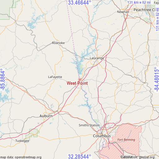
West Point GPS coordinates[2]
32° 52' 40.476" North, 85° 10' 59.772" West
| Map corner | latitude | longitude |
|---|---|---|
| Upper-left | 33.46644°, | -85.8864° |
| Center: | 32.87791°, | -85.18327° |
| Lower-right: | 32.28544°, | -84.48015° |
| Map W x H: | 131.3×131.3 km | = 81.6×81.6mi |
| max Lat: | 71.29058° ⇑85.6% North |
| West Point: | 32.87791° |
| min Lat: | ⇓14.4% South 19.06759° |
| min Long | West Point | max Long |
| -171.73463° | -85.18327° | -66.98998° |
| W 55.4%⇐ | ⇒44.6% E |
Elevation
Elevation of West Point is 178 m = 584 ft, and this is 116.8 m = 383 ft below average elevation for this country.
| Max E: |
3189 m = 10463 ft | 55.5% |
| Avg. | 294.8 m = 967 ft | |
| West Point | 178 m = 584 ft | |
Min E: |
-60 m = -197 ft | 44.5% |
See also: United States elevation on elevation.city.
Geographical zone
West Point is located in North temperate zone (between Tropic of Cancer and the Arctic Circle). Distance of this Northern Tropic circle is 1049.8 km =652.3 mi to South.| Distance of | km | miles | from West Point |
|---|---|---|---|
| North Pole | 6351.4 | 3946.6 | to North |
| Arctic Circle | 3745.5 | 2327.3 | to North |
| Tropic Cancer | 1049.8 | 652.3 | to South |
| Equator | 3655.7 | 2271.5 | to South |


Nearby cities:
15 places around West Point: (largest is in red/bold)
• Auburn
40.8 km =25.4 mi,  223°
223°
• Camp Hill
44.8 km =27.8 mi,  258°
258°
• Franklin
45.1 km =28 mi,  10°
10°
• Hamilton
31.8 km =19.8 mi,  114°
114°
• Hogansville
41.3 km =25.7 mi,  37°
37°
• Huguley
6.5 km =4 mi, 221°
• LaGrange
22.9 km =14.2 mi, 38°
• Lafayette
20.5 km =12.7 mi,  276°
276°
• Lanett
1.2 km =0.7 mi,  213°
213°
• Opelika
31.6 km =19.6 mi, 215°
• Pine Mountain
30.8 km =19.1 mi,  92°
92°
• Roanoke
35.1 km =21.8 mi,  329°
329°
• Rock Mills
32.8 km =20.4 mi,  342°
342°
• Smiths Station
38.4 km =23.9 mi,  168°
168°
• Valley
6.6 km =4.1 mi,  176°
176°
Sources, notices
• [Note1] Compared only with cities in United States existing in our database
• [Src1] Map data: © OpenStreetMap contributors (CC-BY-SA)
• [Src2] Other city data from geonames.org with taken over terms of usage.
• [Src3] Geographical zone / Annual Mean Temperature by Robert A. Rohde @ Wikipedia
