Hardin geodata
Hardin (Illinois) is a seat of a second-order administrative division; located in United States in America/Chicago (GMT-5) time zone. With population of 934 people, there are 16762 cities with bigger population in this country. Compared to other cities in United States, 53.4% of cities are located further ↑North; 61.2% of cities are located further →East and 63.8% of cities have higher elevation than Hardin. Note1


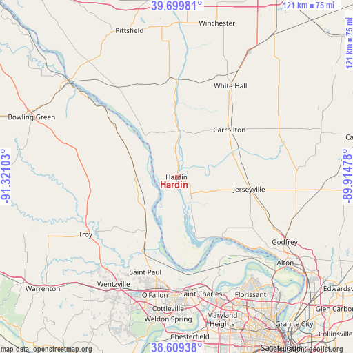
Hardin GPS coordinates[2]
39° 9' 24.156" North, 90° 37' 4.44" West
| Map corner | latitude | longitude |
|---|---|---|
| Upper-left | 39.69981°, | -91.32103° |
| Center: | 39.15671°, | -90.6179° |
| Lower-right: | 38.60938°, | -89.91478° |
| Map W x H: | 121.2×121.2 km | = 75.3×75.3mi |
| max Lat: | 71.29058° ⇑53.4% North |
| Hardin: | 39.15671° |
| min Lat: | ⇓46.6% South 19.06759° |
| min Long | Hardin | max Long |
| -171.73463° | -90.6179° | -66.98998° |
| W 38.8%⇐ | ⇒61.2% E |
Elevation
Elevation of Hardin is 134 m = 440 ft, and this is 160.8 m = 528 ft below average elevation for this country.
| Max E: |
3189 m = 10463 ft | 63.8% |
| Avg. | 294.8 m = 967 ft | |
| Hardin | 134 m = 440 ft | |
Min E: |
-60 m = -197 ft | 36.2% |
See also: United States elevation on elevation.city.
Geographical zone
Hardin is located in North temperate zone (between Tropic of Cancer and the Arctic Circle). Distance of this Northern Tropic circle is 1747.9 km =1086.1 mi to South.| Distance of | km | miles | from Hardin |
|---|---|---|---|
| North Pole | 5653.2 | 3512.7 | to North |
| Arctic Circle | 3047.4 | 1893.6 | to North |
| Tropic Cancer | 1747.9 | 1086.1 | to South |
| Equator | 4353.8 | 2705.3 | to South |


Nearby cities:
15 places around Hardin: (largest is in red/bold)
• Carrollton
24.3 km =15.1 mi,  48°
48°
• Elsah
31.5 km =19.6 mi,  135°
135°
• Elsberry
14.1 km =8.8 mi,  274°
274°
• Eolia
34.8 km =21.6 mi,  284°
284°
• Flint Hill
39.6 km =24.6 mi,  212°
212°
• Grafton
26.3 km =16.3 mi, 142°
• Jerseyville
25.3 km =15.7 mi,  99°
99°
• Moscow Mills
34.8 km =21.6 mi,  228°
228°
• O'Fallon
39.1 km =24.3 mi,  190°
190°
• Pleasant Hill
38.7 km =24 mi,  325°
325°
• Saint Paul
34.5 km =21.4 mi,  198°
198°
• Saint Peters
39.6 km =24.6 mi,  181°
181°
• Troy
37 km =23 mi,  237°
237°
• White Hall
36.2 km =22.5 mi,  30°
30°
• Winfield
20.6 km =12.8 mi, 210°
Sources, notices
• [Note1] Compared only with cities in United States existing in our database
• [Src1] Map data: © OpenStreetMap contributors (CC-BY-SA)
• [Src2] Other city data from geonames.org with taken over terms of usage.
• [Src3] Geographical zone / Annual Mean Temperature by Robert A. Rohde @ Wikipedia
