Center geodata
Center (Texas) is a seat of a second-order administrative division; located in United States in America/Chicago (GMT-5) time zone. With population of 5,211 people, there are 6988 cities with bigger population in this country. Compared to other cities in United States, 89% of cities are located further ↑North; 69.1% of cities are located further →East and 66.9% of cities have higher elevation than Center. Note1


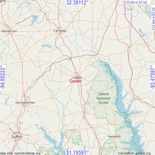
Center GPS coordinates[2]
31° 47' 43.62" North, 94° 10' 44.724" West
| Map corner | latitude | longitude |
|---|---|---|
| Upper-left | 32.39112°, | -94.88222° |
| Center: | 31.79545°, | -94.17909° |
| Lower-right: | 31.19591°, | -93.47597° |
| Map W x H: | 132.9×132.9 km | = 82.6×82.6mi |
| max Lat: | 71.29058° ⇑89% North |
| Center: | 31.79545° |
| min Lat: | ⇓11% South 19.06759° |
| min Long | Center | max Long |
| -171.73463° | -94.17909° | -66.98998° |
| W 30.9%⇐ | ⇒69.1% E |
Elevation
Elevation of Center is 118 m = 387 ft, and this is 176.8 m = 580 ft below average elevation for this country.
| Max E: |
3189 m = 10463 ft | 66.9% |
| Avg. | 294.8 m = 967 ft | |
| Center | 118 m = 387 ft | |
Min E: |
-60 m = -197 ft | 33.1% |
See also: United States elevation on elevation.city.
Geographical zone
Center is located in North temperate zone (between Tropic of Cancer and the Arctic Circle). Distance of this Northern Tropic circle is 929.4 km =577.5 mi to South.| Distance of | km | miles | from Center |
|---|---|---|---|
| North Pole | 6471.7 | 4021.3 | to North |
| Arctic Circle | 3865.9 | 2402.2 | to North |
| Tropic Cancer | 929.4 | 577.5 | to South |
| Equator | 3535.3 | 2196.7 | to South |


Nearby cities:
15 places around Center: (largest is in red/bold)
• Beckville
56.2 km =34.9 mi,  332°
332°
• Carthage
42.9 km =26.7 mi,  339°
339°
• Cushing
62.5 km =38.8 mi,  271°
271°
• Garrison
29.7 km =18.5 mi,  276°
276°
• Hemphill
59.6 km =37 mi,  148°
148°
• Joaquin
22.3 km =13.9 mi,  31°
31°
• Logansport
26.3 km =16.3 mi,  40°
40°
• Mansfield
52.6 km =32.7 mi,  59°
59°
• Milam
51.2 km =31.8 mi,  141°
141°
• Nacogdoches
49.9 km =31 mi,  244°
244°
• Pleasant Hill
62.9 km =39.1 mi,  87°
87°
• San Augustine
30.3 km =18.8 mi,  166°
166°
• Tenaha
17.6 km =10.9 mi, 339°
• Timpson
23.7 km =14.7 mi,  300°
300°
• Zwolle
53.8 km =33.4 mi,  109°
109°
Sources, notices
• [Note1] Compared only with cities in United States existing in our database
• [Src1] Map data: © OpenStreetMap contributors (CC-BY-SA)
• [Src2] Other city data from geonames.org with taken over terms of usage.
• [Src3] Geographical zone / Annual Mean Temperature by Robert A. Rohde @ Wikipedia
