Tenaha geodata
Tenaha (Texas) is a populated place; located in United States in America/Chicago (GMT-5) time zone. With population of 1,152 people, there are 15371 cities with bigger population in this country. Compared to other cities in United States, 88.7% of cities are located further ↑North; 69.2% of cities are located further →East and 68.3% of cities have higher elevation than Tenaha. Note1


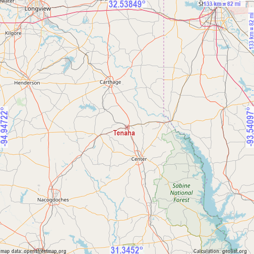
Tenaha GPS coordinates[2]
31° 56' 37.608" North, 94° 14' 38.724" West
| Map corner | latitude | longitude |
|---|---|---|
| Upper-left | 32.53849°, | -94.94722° |
| Center: | 31.94378°, | -94.24409° |
| Lower-right: | 31.3452°, | -93.54097° |
| Map W x H: | 132.7×132.7 km | = 82.5×82.5mi |
| max Lat: | 71.29058° ⇑88.7% North |
| Tenaha: | 31.94378° |
| min Lat: | ⇓11.3% South 19.06759° |
| min Long | Tenaha | max Long |
| -171.73463° | -94.24409° | -66.98998° |
| W 30.8%⇐ | ⇒69.2% E |
Elevation
Elevation of Tenaha is 111 m = 364 ft, and this is 183.8 m = 603 ft below average elevation for this country.
| Max E: |
3189 m = 10463 ft | 68.3% |
| Avg. | 294.8 m = 967 ft | |
| Tenaha | 111 m = 364 ft | |
Min E: |
-60 m = -197 ft | 31.7% |
See also: United States elevation on elevation.city.
Geographical zone
Tenaha is located in North temperate zone (between Tropic of Cancer and the Arctic Circle). Distance of this Northern Tropic circle is 945.9 km =587.8 mi to South.| Distance of | km | miles | from Tenaha |
|---|---|---|---|
| North Pole | 6455.2 | 4011.1 | to North |
| Arctic Circle | 3849.4 | 2391.9 | to North |
| Tropic Cancer | 945.9 | 587.8 | to South |
| Equator | 3551.8 | 2207 | to South |


Nearby cities:
15 places around Tenaha: (largest is in red/bold)
• Beckville
38.8 km =24.1 mi,  329°
329°
• Carthage
25.3 km =15.7 mi,  339°
339°
• Center
17.6 km =10.9 mi,  159°
159°
• Cushing
58.1 km =36.1 mi,  255°
255°
• Easton
58.7 km =36.5 mi, 327°
• Garrison
26.8 km =16.7 mi,  240°
240°
• Henderson
57.3 km =35.6 mi,  293°
293°
• Joaquin
18 km =11.2 mi,  82°
82°
• Logansport
23.5 km =14.6 mi, 81°
• Mansfield
52.3 km =32.5 mi, 78°
• Nacogdoches
54.3 km =33.7 mi,  225°
225°
• San Augustine
47.8 km =29.7 mi, 164°
• Stonewall
54.6 km =33.9 mi,  46°
46°
• Tatum
48.7 km =30.3 mi, 328°
• Timpson
14.9 km =9.3 mi,  252°
252°
Sources, notices
• [Note1] Compared only with cities in United States existing in our database
• [Src1] Map data: © OpenStreetMap contributors (CC-BY-SA)
• [Src2] Other city data from geonames.org with taken over terms of usage.
• [Src3] Geographical zone / Annual Mean Temperature by Robert A. Rohde @ Wikipedia
