Caddo geodata
Caddo (Oklahoma) is a populated place; located in United States in America/Chicago (GMT-5) time zone. With population of 1,048 people, there are 15974 cities with bigger population in this country. Compared to other cities in United States, 79.4% of cities are located further ↑North; 74% of cities are located further →East and 57.5% of cities have lower elevation than Caddo. Note1


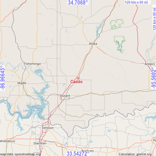
Caddo GPS coordinates[2]
34° 7' 36.336" North, 96° 15' 47.952" West
| Map corner | latitude | longitude |
|---|---|---|
| Upper-left | 34.7068°, | -96.96645° |
| Center: | 34.12676°, | -96.26332° |
| Lower-right: | 33.54272°, | -95.5602° |
| Map W x H: | 129.4×129.4 km | = 80.4×80.4mi |
| max Lat: | 71.29058° ⇑79.4% North |
| Caddo: | 34.12676° |
| min Lat: | ⇓20.6% South 19.06759° |
| min Long | Caddo | max Long |
| -171.73463° | -96.26332° | -66.98998° |
| W 26%⇐ | ⇒74% E |
Elevation
Elevation of Caddo is 228 m = 748 ft, and this is 66.8 m = 219 ft below average elevation for this country.
| Max E: |
3189 m = 10463 ft | 42.5% |
| Avg. | 294.8 m = 967 ft | |
| Caddo | 228 m = 748 ft | |
Min E: |
-60 m = -197 ft | 57.5% |
See also: United States elevation on elevation.city.
Geographical zone
Caddo is located in North temperate zone (between Tropic of Cancer and the Arctic Circle). Distance of this Northern Tropic circle is 1188.6 km =738.6 mi to South.| Distance of | km | miles | from Caddo |
|---|---|---|---|
| North Pole | 6212.5 | 3860.3 | to North |
| Arctic Circle | 3606.6 | 2241 | to North |
| Tropic Cancer | 1188.6 | 738.6 | to South |
| Equator | 3794.5 | 2357.8 | to South |


Nearby cities:
15 places around Caddo: (largest is in red/bold)
• Achille
34.6 km =21.5 mi,  199°
199°
• Atoka
31.4 km =19.5 mi,  23°
23°
• Bokchito
16.5 km =10.3 mi,  137°
137°
• Boswell
37.9 km =23.5 mi,  106°
106°
• Calera
26.2 km =16.3 mi,  215°
215°
• Cartwright
41.1 km =25.5 mi, 222°
• Coalgate
45.9 km =28.5 mi,  5°
5°
• Colbert
37.6 km =23.4 mi, 215°
• Denison
48.4 km =30.1 mi,  211°
211°
• Durant
17.8 km =11.1 mi, 213°
• Kingston
44.4 km =27.6 mi,  251°
251°
• Madill
47 km =29.2 mi,  265°
265°
• Preston
43.6 km =27.1 mi,  231°
231°
• Ravia
46.7 km =29 mi,  285°
285°
• Tishomingo
40.1 km =24.9 mi, 287°
Sources, notices
• [Note1] Compared only with cities in United States existing in our database
• [Src1] Map data: © OpenStreetMap contributors (CC-BY-SA)
• [Src2] Other city data from geonames.org with taken over terms of usage.
• [Src3] Geographical zone / Annual Mean Temperature by Robert A. Rohde @ Wikipedia
