San Augustine geodata
San Augustine (Texas) is a seat of a second-order administrative division; located in United States in America/Chicago (GMT-5) time zone. With population of 2,009 people, there are 11919 cities with bigger population in this country. Compared to other cities in United States, 89.6% of cities are located further ↑North; 68.9% of cities are located further →East and 66.4% of cities have higher elevation than San Augustine. Note1


San Augustine GPS coordinates[2]
31° 31' 47.64" North, 94° 6' 21.708" West
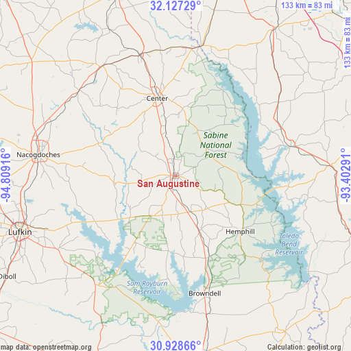
| Map corner | latitude | longitude |
|---|---|---|
| Upper-left | 32.12729°, | -94.80916° |
| Center: | 31.5299°, | -94.10603° |
| Lower-right: | 30.92866°, | -93.40291° |
| Map W x H: | 133.3×133.3 km | = 82.8×82.8mi |
| max Lat: | 71.29058° ⇑89.6% North |
| San Augustine: | 31.5299° |
| min Lat: | ⇓10.4% South 19.06759° |
| min Long | San Augustine | max Long |
| -171.73463° | -94.10603° | -66.98998° |
| W 31.1%⇐ | ⇒68.9% E |
Elevation
Elevation of San Augustine is 121 m = 397 ft, and this is 173.8 m = 570 ft below average elevation for this country.
| Max E: |
3189 m = 10463 ft | 66.4% |
| Avg. | 294.8 m = 967 ft | |
| San Augustine | 121 m = 397 ft | |
Min E: |
-60 m = -197 ft | 33.6% |
See also: United States elevation on elevation.city.
Geographical zone
San Augustine is located in North temperate zone (between Tropic of Cancer and the Arctic Circle). Distance of this Northern Tropic circle is 899.9 km =559.2 mi to South.| Distance of | km | miles | from San Augustine |
|---|---|---|---|
| North Pole | 6501.3 | 4039.7 | to North |
| Arctic Circle | 3895.4 | 2420.5 | to North |
| Tropic Cancer | 899.9 | 559.2 | to South |
| Equator | 3505.8 | 2178.4 | to South |


Nearby cities:
15 places around San Augustine: (largest is in red/bold)
• Center
30.3 km =18.8 mi,  346°
346°
• Garrison
49 km =30.4 mi,  311°
311°
• Hemphill
32.4 km =20.1 mi,  130°
130°
• Huntington
52.7 km =32.7 mi,  237°
237°
• Joaquin
48.7 km =30.3 mi,  5°
5°
• Logansport
50.6 km =31.4 mi, 11°
• Many
59.1 km =36.7 mi,  85°
85°
• Milam
27 km =16.8 mi,  113°
113°
• Nacogdoches
52.7 km =32.7 mi,  278°
278°
• Pineland
33.7 km =20.9 mi,  158°
158°
• Sam Rayburn
52.2 km =32.4 mi,  172°
172°
• Tenaha
47.8 km =29.7 mi,  344°
344°
• Timpson
49.8 km =30.9 mi,  326°
326°
• Zavalla
51.3 km =31.9 mi,  216°
216°
• Zwolle
45.2 km =28.1 mi,  75°
75°
Sources, notices
• [Note1] Compared only with cities in United States existing in our database
• [Src1] Map data: © OpenStreetMap contributors (CC-BY-SA)
• [Src2] Other city data from geonames.org with taken over terms of usage.
• [Src3] Geographical zone / Annual Mean Temperature by Robert A. Rohde @ Wikipedia
