Coalgate geodata
Coalgate (Oklahoma) is a seat of a second-order administrative division; located in United States in America/Chicago (GMT-5) time zone. With population of 1,867 people, there are 12319 cities with bigger population in this country. Compared to other cities in United States, 77.5% of cities are located further ↑North; 73.9% of cities are located further →East and 51.4% of cities have higher elevation than Coalgate. Note1


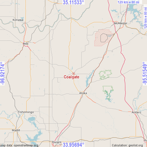
Coalgate GPS coordinates[2]
34° 32' 17.34" North, 96° 13' 6.996" West
| Map corner | latitude | longitude |
|---|---|---|
| Upper-left | 35.11533°, | -96.92174° |
| Center: | 34.53815°, | -96.21861° |
| Lower-right: | 33.95694°, | -95.51549° |
| Map W x H: | 128.8×128.8 km | = 80×80mi |
| max Lat: | 71.29058° ⇑77.5% North |
| Coalgate: | 34.53815° |
| min Lat: | ⇓22.5% South 19.06759° |
| min Long | Coalgate | max Long |
| -171.73463° | -96.21861° | -66.98998° |
| W 26.1%⇐ | ⇒73.9% E |
Elevation
Elevation of Coalgate is 193 m = 633 ft, and this is 101.8 m = 334 ft below average elevation for this country.
| Max E: |
3189 m = 10463 ft | 51.4% |
| Avg. | 294.8 m = 967 ft | |
| Coalgate | 193 m = 633 ft | |
Min E: |
-60 m = -197 ft | 48.6% |
See also: United States elevation on elevation.city.
Geographical zone
Coalgate is located in North temperate zone (between Tropic of Cancer and the Arctic Circle). Distance of this Northern Tropic circle is 1234.4 km =767 mi to South.| Distance of | km | miles | from Coalgate |
|---|---|---|---|
| North Pole | 6166.8 | 3831.9 | to North |
| Arctic Circle | 3560.9 | 2212.6 | to North |
| Tropic Cancer | 1234.4 | 767 | to South |
| Equator | 3840.3 | 2386.3 | to South |


Nearby cities:
15 places around Coalgate: (largest is in red/bold)
• Ada
49.6 km =30.8 mi,  302°
302°
• Allen
41.8 km =26 mi,  334°
334°
• Atoka
18.8 km =11.7 mi,  153°
153°
• Bokchito
58.3 km =36.2 mi,  173°
173°
• Byng
54.4 km =33.8 mi,  311°
311°
• Caddo
45.9 km =28.5 mi,  185°
185°
• Durant
62.1 km =38.6 mi, 193°
• Holdenville
62.5 km =38.8 mi,  344°
344°
• Kiowa
35.6 km =22.1 mi,  55°
55°
• Krebs
63.2 km =39.3 mi,  46°
46°
• McAlester
60.1 km =37.3 mi,  43°
43°
• Ravia
59 km =36.7 mi,  236°
236°
• Roff
57.8 km =35.9 mi,  279°
279°
• Savanna
47.1 km =29.3 mi, 46°
• Tishomingo
53.9 km =33.5 mi,  231°
231°
Sources, notices
• [Note1] Compared only with cities in United States existing in our database
• [Src1] Map data: © OpenStreetMap contributors (CC-BY-SA)
• [Src2] Other city data from geonames.org with taken over terms of usage.
• [Src3] Geographical zone / Annual Mean Temperature by Robert A. Rohde @ Wikipedia
