Luverne geodata
Luverne (Alabama) is a seat of a second-order administrative division; located in United States in America/Chicago (GMT-5) time zone. With population of 2,834 people, there are 9938 cities with bigger population in this country. Compared to other cities in United States, 89.2% of cities are located further ↑North; 52.2% of cities are located further ←West and 68.3% of cities have higher elevation than Luverne. Note1


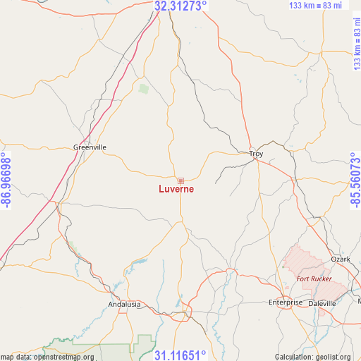
Luverne GPS coordinates[2]
31° 42' 59.58" North, 86° 15' 49.86" West
| Map corner | latitude | longitude |
|---|---|---|
| Upper-left | 32.31273°, | -86.96698° |
| Center: | 31.71655°, | -86.26385° |
| Lower-right: | 31.11651°, | -85.56073° |
| Map W x H: | 133×133 km | = 82.6×82.6mi |
| max Lat: | 71.29058° ⇑89.2% North |
| Luverne: | 31.71655° |
| min Lat: | ⇓10.8% South 19.06759° |
| min Long | Luverne | max Long |
| -171.73463° | -86.26385° | -66.98998° |
| W 52.2%⇐ | ⇒47.8% E |
Elevation
Elevation of Luverne is 111 m = 364 ft, and this is 183.8 m = 603 ft below average elevation for this country.
| Max E: |
3189 m = 10463 ft | 68.3% |
| Avg. | 294.8 m = 967 ft | |
| Luverne | 111 m = 364 ft | |
Min E: |
-60 m = -197 ft | 31.7% |
See also: United States elevation on elevation.city.
Geographical zone
Luverne is located in North temperate zone (between Tropic of Cancer and the Arctic Circle). Distance of this Northern Tropic circle is 920.6 km =572 mi to South.| Distance of | km | miles | from Luverne |
|---|---|---|---|
| North Pole | 6480.5 | 4026.8 | to North |
| Arctic Circle | 3874.6 | 2407.6 | to North |
| Tropic Cancer | 920.6 | 572 | to South |
| Equator | 3526.5 | 2191.3 | to South |


Nearby cities:
15 places around Luverne: (largest is in red/bold)
• Babbie
48.9 km =30.4 mi,  186°
186°
• Brantley
14.9 km =9.3 mi,  177°
177°
• Brundidge
42.4 km =26.3 mi,  89°
89°
• Elba
38.4 km =23.9 mi,  151°
151°
• Fort Deposit
42.1 km =26.2 mi,  315°
315°
• Georgiana
46.1 km =28.6 mi,  258°
258°
• Greenville
35.7 km =22.2 mi,  290°
290°
• Joquin
12.2 km =7.6 mi,  50°
50°
• McKenzie
46.9 km =29.1 mi,  245°
245°
• New Brockton
48.6 km =30.2 mi,  139°
139°
• Opp
48.2 km =30 mi, 179°
• Pisgah
34.1 km =21.2 mi,  23°
23°
• River Falls
48.2 km =30 mi,  213°
213°
• Taylor
28.9 km =18 mi,  5°
5°
• Troy
29.6 km =18.4 mi,  69°
69°
Sources, notices
• [Note1] Compared only with cities in United States existing in our database
• [Src1] Map data: © OpenStreetMap contributors (CC-BY-SA)
• [Src2] Other city data from geonames.org with taken over terms of usage.
• [Src3] Geographical zone / Annual Mean Temperature by Robert A. Rohde @ Wikipedia
