Fortuna Foothills geodata
Fortuna Foothills (Arizona) is a populated place; located in United States in America/Phoenix (GMT-7) time zone. With population of 26,265 people, there are 1910 cities with bigger population in this country. Compared to other cities in United States, 86.6% of cities are located further ↑North; 88.7% of cities are located further →East and 70.3% of cities have higher elevation than Fortuna Foothills. Note1


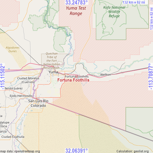
Fortuna Foothills GPS coordinates[2]
32° 39' 28.188" North, 114° 24' 42.804" West
| Map corner | latitude | longitude |
|---|---|---|
| Upper-left | 33.24783°, | -115.11502° |
| Center: | 32.65783°, | -114.41189° |
| Lower-right: | 32.06391°, | -113.70877° |
| Map W x H: | 131.6×131.6 km | = 81.8×81.8mi |
| max Lat: | 71.29058° ⇑86.6% North |
| Fortuna Foothills: | 32.65783° |
| min Lat: | ⇓13.4% South 19.06759° |
| min Long | Fortuna Foothil | max Long |
| -171.73463° | -114.41189° | -66.98998° |
| W 11.3%⇐ | ⇒88.7% E |
Elevation
Elevation of Fortuna Foothills is 99 m = 325 ft, and this is 195.8 m = 642 ft below average elevation for this country.
| Max E: |
3189 m = 10463 ft | 70.3% |
| Avg. | 294.8 m = 967 ft | |
| Fortuna Foothills | 99 m = 325 ft | |
Min E: |
-60 m = -197 ft | 29.7% |
See also: United States elevation on elevation.city.
Geographical zone
Fortuna Foothills is located in North temperate zone (between Tropic of Cancer and the Arctic Circle). Distance of this Northern Tropic circle is 1025.3 km =637.1 mi to South.| Distance of | km | miles | from Fortuna Foothills |
|---|---|---|---|
| North Pole | 6375.9 | 3961.8 | to North |
| Arctic Circle | 3770 | 2342.6 | to North |
| Tropic Cancer | 1025.3 | 637.1 | to South |
| Equator | 3631.2 | 2256.3 | to South |


Nearby cities:
15 places around Fortuna Foothills: (largest is in red/bold)
• Avenue B and C
24.2 km =15 mi,  286°
286°
• Calexico
101.8 km =63.3 mi,  271°
271°
• Donovan Estates
25.6 km =15.9 mi,  282°
282°
• El Prado Estates
11.6 km =7.2 mi,  297°
297°
• Gadsden
36.8 km =22.9 mi,  251°
251°
• Holtville
92.2 km =57.3 mi, 280°
• La Paz Valley
103.4 km =64.2 mi,  8°
8°
• Orange Grove Mobile Manor
24.2 km =15 mi, 254°
• Rancho Mesa Verde
23.8 km =14.8 mi, 252°
• Ripley
99.1 km =61.6 mi,  346°
346°
• San Luis
39.6 km =24.6 mi,  241°
241°
• Somerton
28.7 km =17.8 mi,  256°
256°
• Tacna
43.1 km =26.8 mi,  84°
84°
• Wellton
24.9 km =15.5 mi,  86°
86°
• Yuma
21.3 km =13.2 mi, 290°
Sources, notices
• [Note1] Compared only with cities in United States existing in our database
• [Src1] Map data: © OpenStreetMap contributors (CC-BY-SA)
• [Src2] Other city data from geonames.org with taken over terms of usage.
• [Src3] Geographical zone / Annual Mean Temperature by Robert A. Rohde @ Wikipedia
