Gadsden geodata
Gadsden (Arizona) is a populated place; located in United States in America/Phoenix (GMT-7) time zone. With population of 678 people, there are 18889 cities with bigger population in this country. Compared to other cities in United States, 86.9% of cities are located further ↑North; 88.9% of cities are located further →East and 84.8% of cities have higher elevation than Gadsden. Note1


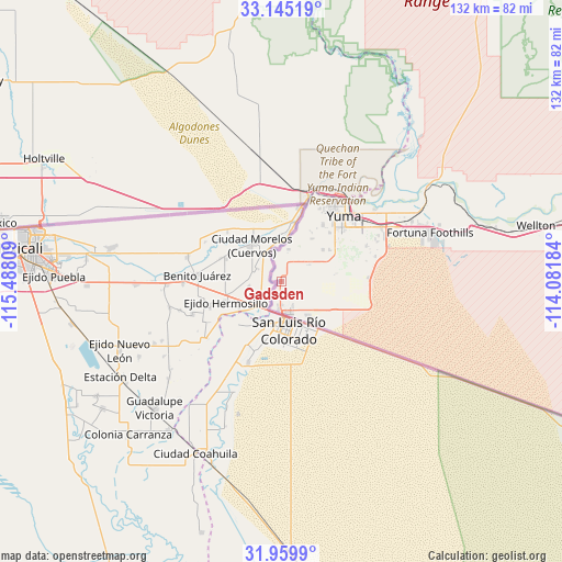
Gadsden GPS coordinates[2]
32° 33' 16.2" North, 114° 47' 5.856" West
| Map corner | latitude | longitude |
|---|---|---|
| Upper-left | 33.14519°, | -115.48809° |
| Center: | 32.5545°, | -114.78496° |
| Lower-right: | 31.9599°, | -114.08184° |
| Map W x H: | 131.8×131.8 km | = 81.9×81.9mi |
| max Lat: | 71.29058° ⇑86.9% North |
| Gadsden: | 32.5545° |
| min Lat: | ⇓13.1% South 19.06759° |
| min Long | Gadsden | max Long |
| -171.73463° | -114.78496° | -66.98998° |
| W 11.1%⇐ | ⇒88.9% E |
Elevation
Elevation of Gadsden is 29 m = 95 ft, and this is 265.8 m = 872 ft below average elevation for this country.
| Max E: |
3189 m = 10463 ft | 84.8% |
| Avg. | 294.8 m = 967 ft | |
| Gadsden | 29 m = 95 ft | |
Min E: |
-60 m = -197 ft | 15.2% |
See also: United States elevation on elevation.city.
Geographical zone
Gadsden is located in North temperate zone (between Tropic of Cancer and the Arctic Circle). Distance of this Northern Tropic circle is 1013.8 km =629.9 mi to South.| Distance of | km | miles | from Gadsden |
|---|---|---|---|
| North Pole | 6387.3 | 3968.9 | to North |
| Arctic Circle | 3781.5 | 2349.7 | to North |
| Tropic Cancer | 1013.8 | 629.9 | to South |
| Equator | 3619.7 | 2249.2 | to South |


Nearby cities:
15 places around Gadsden: (largest is in red/bold)
• Avenue B and C
21.7 km =13.5 mi,  32°
32°
• Calexico
68.3 km =42.4 mi,  281°
281°
• Donovan Estates
19.9 km =12.4 mi, 30°
• El Centro
77.5 km =48.2 mi,  289°
289°
• El Prado Estates
29.9 km =18.6 mi,  55°
55°
• Fortuna Foothills
36.8 km =22.9 mi,  71°
71°
• Heber
72.4 km =45 mi, 285°
• Holtville
62.6 km =38.9 mi,  297°
297°
• Orange Grove Mobile Manor
12.6 km =7.8 mi, 67°
• Rancho Mesa Verde
13 km =8.1 mi, 69°
• San Luis
7.5 km =4.7 mi,  178°
178°
• Somerton
8.5 km =5.3 mi, 56°
• Tacna
79.5 km =49.4 mi,  78°
78°
• Wellton
61.2 km =38 mi, 77°
• Yuma
24.2 km =15 mi,  38°
38°
Sources, notices
• [Note1] Compared only with cities in United States existing in our database
• [Src1] Map data: © OpenStreetMap contributors (CC-BY-SA)
• [Src2] Other city data from geonames.org with taken over terms of usage.
• [Src3] Geographical zone / Annual Mean Temperature by Robert A. Rohde @ Wikipedia
