Donovan Estates geodata
Donovan Estates (Arizona) is a populated place; located in United States in America/Phoenix (GMT-7) time zone. With population of 1,508 people, there are 13621 cities with bigger population in this country. Compared to other cities in United States, 86.4% of cities are located further ↑North; 88.8% of cities are located further →East and 82.3% of cities have higher elevation than Donovan Estates. Note1


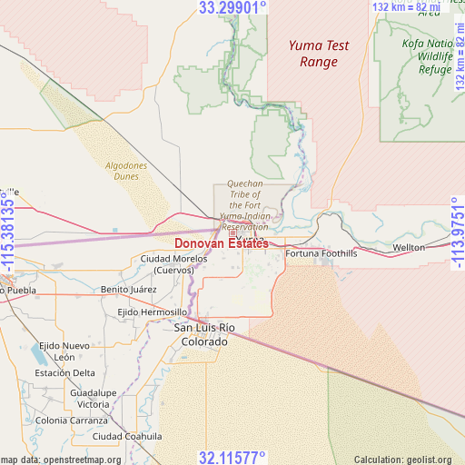
Donovan Estates GPS coordinates[2]
32° 42' 33.66" North, 114° 40' 41.592" West
| Map corner | latitude | longitude |
|---|---|---|
| Upper-left | 33.29901°, | -115.38135° |
| Center: | 32.70935°, | -114.67822° |
| Lower-right: | 32.11577°, | -113.9751° |
| Map W x H: | 131.6×131.6 km | = 81.8×81.8mi |
| max Lat: | 71.29058° ⇑86.4% North |
| Donovan Estates: | 32.70935° |
| min Lat: | ⇓13.6% South 19.06759° |
| min Long | Donovan Estates | max Long |
| -171.73463° | -114.67822° | -66.98998° |
| W 11.2%⇐ | ⇒88.8% E |
Elevation
Elevation of Donovan Estates is 37 m = 121 ft, and this is 257.8 m = 846 ft below average elevation for this country.
| Max E: |
3189 m = 10463 ft | 82.3% |
| Avg. | 294.8 m = 967 ft | |
| Donovan Estates | 37 m = 121 ft | |
Min E: |
-60 m = -197 ft | 17.7% |
See also: United States elevation on elevation.city.
Geographical zone
Donovan Estates is located in North temperate zone (between Tropic of Cancer and the Arctic Circle). Distance of this Northern Tropic circle is 1031 km =640.6 mi to South.| Distance of | km | miles | from Donovan Estates |
|---|---|---|---|
| North Pole | 6370.1 | 3958.2 | to North |
| Arctic Circle | 3764.2 | 2339 | to North |
| Tropic Cancer | 1031 | 640.6 | to South |
| Equator | 3636.9 | 2259.9 | to South |


Nearby cities:
15 places around Donovan Estates: (largest is in red/bold)
• Avenue B and C
2 km =1.2 mi,  57°
57°
• Calexico
76.9 km =47.8 mi,  267°
267°
• El Centro
83.3 km =51.8 mi,  276°
276°
• El Prado Estates
14.7 km =9.1 mi,  91°
91°
• Fortuna Foothills
25.6 km =15.9 mi,  102°
102°
• Gadsden
19.9 km =12.4 mi,  210°
210°
• Heber
79.7 km =49.5 mi, 271°
• Holtville
66.6 km =41.4 mi, 279°
• Orange Grove Mobile Manor
12.4 km =7.7 mi,  172°
172°
• Rancho Mesa Verde
13 km =8.1 mi, 170°
• San Luis
26.6 km =16.5 mi,  201°
201°
• Somerton
12.9 km =8 mi,  193°
193°
• Tacna
67.8 km =42.1 mi, 91°
• Wellton
49.9 km =31 mi, 94°
• Yuma
5.3 km =3.3 mi,  70°
70°
Sources, notices
• [Note1] Compared only with cities in United States existing in our database
• [Src1] Map data: © OpenStreetMap contributors (CC-BY-SA)
• [Src2] Other city data from geonames.org with taken over terms of usage.
• [Src3] Geographical zone / Annual Mean Temperature by Robert A. Rohde @ Wikipedia
