Yuma geodata
Yuma (Arizona) is a seat of a second-order administrative division; located in United States in America/Phoenix (GMT-7) time zone. With population of 94,139 people, there are 383 cities with bigger population in this country. Compared to other cities in United States, 86.3% of cities are located further ↑North; 88.8% of cities are located further →East and 80.9% of cities have higher elevation than Yuma. Note1


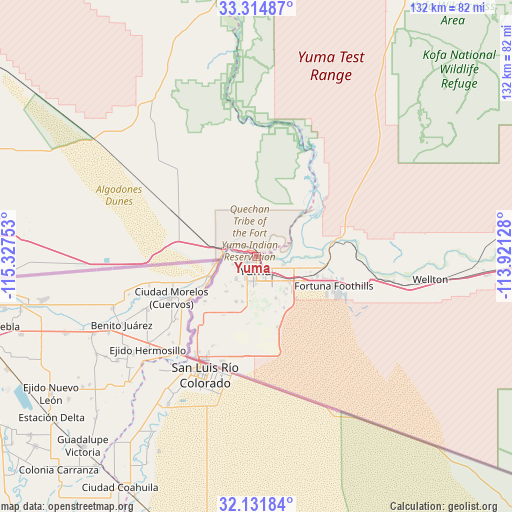
Yuma GPS coordinates[2]
32° 43' 31.152" North, 114° 37' 27.84" West
| Map corner | latitude | longitude |
|---|---|---|
| Upper-left | 33.31487°, | -115.32753° |
| Center: | 32.72532°, | -114.6244° |
| Lower-right: | 32.13184°, | -113.92128° |
| Map W x H: | 131.5×131.5 km | = 81.7×81.7mi |
| max Lat: | 71.29058° ⇑86.3% North |
| Yuma: | 32.72532° |
| min Lat: | ⇓13.7% South 19.06759° |
| min Long | Yuma | max Long |
| -171.73463° | -114.6244° | -66.98998° |
| W 11.2%⇐ | ⇒88.8% E |
Elevation
Elevation of Yuma is 43 m = 141 ft, and this is 251.8 m = 826 ft below average elevation for this country.
| Max E: |
3189 m = 10463 ft | 80.9% |
| Avg. | 294.8 m = 967 ft | |
| Yuma | 43 m = 141 ft | |
Min E: |
-60 m = -197 ft | 19.1% |
See also: Yuma elevation on elevation.city.
Geographical zone
Yuma is located in North temperate zone (between Tropic of Cancer and the Arctic Circle). Distance of this Northern Tropic circle is 1032.8 km =641.8 mi to South.| Distance of | km | miles | from Yuma |
|---|---|---|---|
| North Pole | 6368.3 | 3957.1 | to North |
| Arctic Circle | 3762.5 | 2337.9 | to North |
| Tropic Cancer | 1032.8 | 641.8 | to South |
| Equator | 3638.7 | 2261 | to South |


Nearby cities:
15 places around Yuma: (largest is in red/bold)
• Avenue B and C
3.4 km =2.1 mi,  258°
258°
• Calexico
82 km =51 mi,  266°
266°
• Donovan Estates
5.3 km =3.3 mi,  250°
250°
• El Centro
88.1 km =54.7 mi, 274°
• El Prado Estates
9.9 km =6.2 mi,  102°
102°
• Fortuna Foothills
21.3 km =13.2 mi,  110°
110°
• Gadsden
24.2 km =15 mi,  218°
218°
• Heber
84.7 km =52.6 mi, 270°
• Holtville
71.3 km =44.3 mi,  277°
277°
• Orange Grove Mobile Manor
14.5 km =9 mi,  193°
193°
• Rancho Mesa Verde
14.8 km =9.2 mi, 191°
• San Luis
30.3 km =18.8 mi,  209°
209°
• Somerton
16.4 km =10.2 mi, 209°
• Tacna
62.8 km =39 mi,  92°
92°
• Wellton
45.1 km =28 mi, 97°
Sources, notices
• [Note1] Compared only with cities in United States existing in our database
• [Src1] Map data: © OpenStreetMap contributors (CC-BY-SA)
• [Src2] Other city data from geonames.org with taken over terms of usage.
• [Src3] Geographical zone / Annual Mean Temperature by Robert A. Rohde @ Wikipedia
