Mohall geodata
Mohall (North Dakota) is a seat of a second-order administrative division; located in United States in America/Chicago (GMT-5) time zone. With population of 808 people, there are 17736 cities with bigger population in this country. Compared to other cities in United States, 99.3% of cities are located further ↓South; 81.6% of cities are located further →East and 87.9% of cities have lower elevation than Mohall. Note1


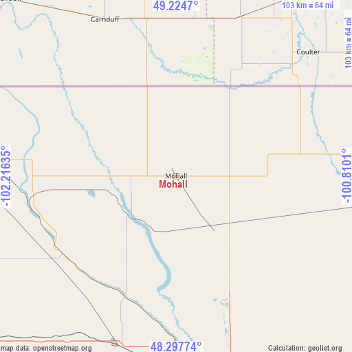
Mohall GPS coordinates[2]
48° 45' 48.096" North, 101° 30' 47.592" West
| Map corner | latitude | longitude |
|---|---|---|
| Upper-left | 49.2247°, | -102.21635° |
| Center: | 48.76336°, | -101.51322° |
| Lower-right: | 48.29774°, | -100.8101° |
| Map W x H: | 103.1×103.1 km | = 64.1×64.1mi |
| max Lat: | 71.29058° ⇑0.7% North |
| Mohall: | 48.76336° |
| min Lat: | ⇓99.3% South 19.06759° |
| min Long | Mohall | max Long |
| -171.73463° | -101.51322° | -66.98998° |
| W 18.4%⇐ | ⇒81.6% E |
Elevation
Elevation of Mohall is 501 m = 1644 ft, and this is 206.2 m = 677 ft above average elevation for this country.
| Max E: |
3189 m = 10463 ft | 12.1% |
| Mohall | 501 m 1644 ft | |
| Avg. | 294.8 m = 967 ft | |
Min E: |
-60 m = -197 ft | 87.9% |
See also: United States elevation on elevation.city.
Geographical zone
Mohall is located in North temperate zone (between Tropic of Cancer and the Arctic Circle). Distance of this North polar circle is 1979.2 km =1229.8 mi to North.| Distance of | km | miles | from Mohall |
|---|---|---|---|
| North Pole | 4585.1 | 2849 | to North |
| Arctic Circle | 1979.2 | 1229.8 | to North |
| Tropic Cancer | 2816.1 | 1749.8 | to South |
| Equator | 5422 | 3369.1 | to South |


Nearby cities:
15 places around Mohall: (largest is in red/bold)
• Berthold
52.7 km =32.7 mi,  198°
198°
• Bottineau
78.5 km =48.8 mi,  84°
84°
• Bowbells
53.9 km =33.5 mi,  274°
274°
• Burlington
54.6 km =33.9 mi,  173°
173°
• Dunseith
106.5 km =66.2 mi,  87°
87°
• Kenmare
42.9 km =26.7 mi,  256°
256°
• Minot
61.2 km =38 mi,  164°
164°
• Minot Air Force Base
40.2 km =25 mi, 161°
• New Town
113 km =70.2 mi,  219°
219°
• Parshall
101.1 km =62.8 mi,  207°
207°
• Stanley
81.4 km =50.6 mi,  232°
232°
• Surrey
64.9 km =40.3 mi,  154°
154°
• Tioga
112.4 km =69.8 mi,  248°
248°
• Towner
93.8 km =58.3 mi,  119°
119°
• Velva
89.7 km =55.7 mi, 151°
Sources, notices
• [Note1] Compared only with cities in United States existing in our database
• [Src1] Map data: © OpenStreetMap contributors (CC-BY-SA)
• [Src2] Other city data from geonames.org with taken over terms of usage.
• [Src3] Geographical zone / Annual Mean Temperature by Robert A. Rohde @ Wikipedia
