Wells geodata
Wells (Nevada) is a populated place; located in United States in America/Los_Angeles (GMT-7) time zone. With population of 1,261 people, there are 14785 cities with bigger population in this country. Compared to other cities in United States, 67% of cities are located further ↓South; 88.9% of cities are located further →East and 98% of cities have lower elevation than Wells. Note1


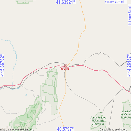
Wells GPS coordinates[2]
41° 6' 41.724" North, 114° 57' 52.164" West
| Map corner | latitude | longitude |
|---|---|---|
| Upper-left | 41.63921°, | -115.66762° |
| Center: | 41.11159°, | -114.96449° |
| Lower-right: | 40.5797°, | -114.26137° |
| Map W x H: | 117.8×117.8 km | = 73.2×73.2mi |
| max Lat: | 71.29058° ⇑33% North |
| Wells: | 41.11159° |
| min Lat: | ⇓67% South 19.06759° |
| min Long | Wells | max Long |
| -171.73463° | -114.96449° | -66.98998° |
| W 11.1%⇐ | ⇒88.9% E |
Elevation
Elevation of Wells is 1720 m = 5643 ft, and this is 1425.2 m = 4676 ft above average elevation for this country.
| Max E: |
3189 m = 10463 ft | 2% |
| Wells | 1720 m 5643 ft | |
| Avg. | 294.8 m = 967 ft | |
Min E: |
-60 m = -197 ft | 98% |
See also: United States elevation on elevation.city.
Geographical zone
Wells is located in North temperate zone (between Tropic of Cancer and the Arctic Circle). Distance of this Northern Tropic circle is 1965.3 km =1221.2 mi to South.| Distance of | km | miles | from Wells |
|---|---|---|---|
| North Pole | 5435.9 | 3377.7 | to North |
| Arctic Circle | 2830 | 1758.5 | to North |
| Tropic Cancer | 1965.3 | 1221.2 | to South |
| Equator | 4571.2 | 2840.4 | to South |


Nearby cities:
15 places around Wells: (largest is in red/bold)
• Battle Mountain
173.6 km =107.9 mi,  252°
252°
• Buhl
166.3 km =103.3 mi,  5°
5°
• Carlin
105.5 km =65.6 mi, 245°
• Elko
73.9 km =45.9 mi, 245°
• Filer
164.8 km =102.4 mi, 10°
• Hansen
167.1 km =103.8 mi,  19°
19°
• Jackpot
99.9 km =62.1 mi, 13°
• Kimberly
165.8 km =103 mi, 17°
• Oakley
154.6 km =96.1 mi,  35°
35°
• Osino
61.7 km =38.3 mi, 251°
• Owyhee
132.5 km =82.3 mi,  314°
314°
• Spring Creek
67.5 km =41.9 mi,  230°
230°
• Twin Falls
166.7 km =103.6 mi, 14°
• Wendover
88.3 km =54.9 mi,  118°
118°
• West Wendover
85.6 km =53.2 mi, 118°
Sources, notices
• [Note1] Compared only with cities in United States existing in our database
• [Src1] Map data: © OpenStreetMap contributors (CC-BY-SA)
• [Src2] Other city data from geonames.org with taken over terms of usage.
• [Src3] Geographical zone / Annual Mean Temperature by Robert A. Rohde @ Wikipedia
