Wendover geodata
Wendover (Utah) is a populated place; located in United States in America/Denver (GMT-6) time zone. With population of 1,400 people, there are 14111 cities with bigger population in this country. Compared to other cities in United States, 62.1% of cities are located further ↓South; 88.4% of cities are located further →East and 95.3% of cities have lower elevation than Wendover. Note1


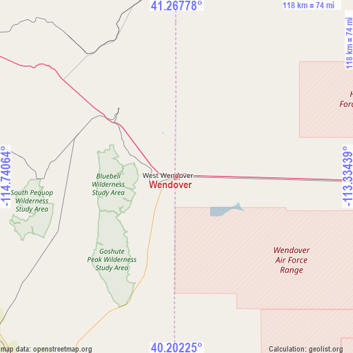
Wendover GPS coordinates[2]
40° 44' 13.74" North, 114° 2' 15.036" West
| Map corner | latitude | longitude |
|---|---|---|
| Upper-left | 41.26778°, | -114.74064° |
| Center: | 40.73715°, | -114.03751° |
| Lower-right: | 40.20225°, | -113.33439° |
| Map W x H: | 118.5×118.5 km | = 73.6×73.6mi |
| max Lat: | 71.29058° ⇑37.9% North |
| Wendover: | 40.73715° |
| min Lat: | ⇓62.1% South 19.06759° |
| min Long | Wendover | max Long |
| -171.73463° | -114.03751° | -66.98998° |
| W 11.6%⇐ | ⇒88.4% E |
Elevation
Elevation of Wendover is 1312 m = 4304 ft, and this is 1017.2 m = 3337 ft above average elevation for this country.
| Max E: |
3189 m = 10463 ft | 4.7% |
| Wendover | 1312 m 4304 ft | |
| Avg. | 294.8 m = 967 ft | |
Min E: |
-60 m = -197 ft | 95.3% |
See also: United States elevation on elevation.city.
Geographical zone
Wendover is located in North temperate zone (between Tropic of Cancer and the Arctic Circle). Distance of this Northern Tropic circle is 1923.6 km =1195.3 mi to South.| Distance of | km | miles | from Wendover |
|---|---|---|---|
| North Pole | 5477.5 | 3403.6 | to North |
| Arctic Circle | 2871.6 | 1784.3 | to North |
| Tropic Cancer | 1923.6 | 1195.3 | to South |
| Equator | 4529.5 | 2814.5 | to South |


Nearby cities:
15 places around Wendover: (largest is in red/bold)
• Bingham Canyon
162.1 km =100.7 mi,  97°
97°
• Dugway
123.5 km =76.7 mi,  117°
117°
• Elko
145.7 km =90.5 mi,  274°
274°
• Erda
146.8 km =91.2 mi, 95°
• Grantsville
133.5 km =83 mi, 96°
• Jackpot
148.4 km =92.2 mi,  339°
339°
• Magna
163.2 km =101.4 mi,  91°
91°
• McGill
161 km =100 mi,  203°
203°
• Osino
138.3 km =85.9 mi,  279°
279°
• Spring Creek
130.5 km =81.1 mi, 269°
• Stansbury park
147.2 km =91.5 mi, 94°
• Stockton
145.1 km =90.2 mi, 102°
• Tooele
148.5 km =92.3 mi, 98°
• Wells
88.3 km =54.9 mi,  298°
298°
• West Wendover
3 km =1.9 mi, 274°
Sources, notices
• [Note1] Compared only with cities in United States existing in our database
• [Src1] Map data: © OpenStreetMap contributors (CC-BY-SA)
• [Src2] Other city data from geonames.org with taken over terms of usage.
• [Src3] Geographical zone / Annual Mean Temperature by Robert A. Rohde @ Wikipedia
