Carlin geodata
Carlin (Nevada) is a populated place; located in United States in America/Los_Angeles (GMT-7) time zone. With population of 2,302 people, there are 11073 cities with bigger population in this country. Compared to other cities in United States, 61.8% of cities are located further ↓South; 89.2% of cities are located further →East and 96.7% of cities have lower elevation than Carlin. Note1


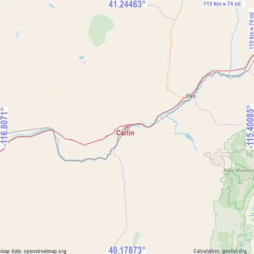
Carlin GPS coordinates[2]
40° 42' 49.716" North, 116° 6' 14.292" West
| Map corner | latitude | longitude |
|---|---|---|
| Upper-left | 41.24463°, | -116.8071° |
| Center: | 40.71381°, | -116.10397° |
| Lower-right: | 40.17873°, | -115.40085° |
| Map W x H: | 118.5×118.5 km | = 73.6×73.6mi |
| max Lat: | 71.29058° ⇑38.2% North |
| Carlin: | 40.71381° |
| min Lat: | ⇓61.8% South 19.06759° |
| min Long | Carlin | max Long |
| -171.73463° | -116.10397° | -66.98998° |
| W 10.8%⇐ | ⇒89.2% E |
Elevation
Elevation of Carlin is 1496 m = 4908 ft, and this is 1201.2 m = 3941 ft above average elevation for this country.
| Max E: |
3189 m = 10463 ft | 3.3% |
| Carlin | 1496 m 4908 ft | |
| Avg. | 294.8 m = 967 ft | |
Min E: |
-60 m = -197 ft | 96.7% |
See also: United States elevation on elevation.city.
Geographical zone
Carlin is located in North temperate zone (between Tropic of Cancer and the Arctic Circle). Distance of this Northern Tropic circle is 1921 km =1193.7 mi to South.| Distance of | km | miles | from Carlin |
|---|---|---|---|
| North Pole | 5480.1 | 3405.2 | to North |
| Arctic Circle | 2874.2 | 1785.9 | to North |
| Tropic Cancer | 1921 | 1193.7 | to South |
| Equator | 4527 | 2812.9 | to South |


Nearby cities:
15 places around Carlin: (largest is in red/bold)
• Battle Mountain
70.5 km =43.8 mi,  263°
263°
• Buhl
237.5 km =147.6 mi,  28°
28°
• Elko
31.6 km =19.6 mi,  65°
65°
• Ely
193.1 km =120 mi,  147°
147°
• Eureka
134.1 km =83.3 mi,  174°
174°
• Jackpot
184.8 km =114.8 mi,  40°
40°
• Lovelock
209.1 km =129.9 mi,  253°
253°
• McGill
184.1 km =114.4 mi,  142°
142°
• Osino
44.5 km =27.7 mi,  56°
56°
• Owyhee
137.2 km =85.3 mi,  0°
0°
• Spring Creek
43.7 km =27.2 mi,  88°
88°
• Wells
105.5 km =65.6 mi, 65°
• Wendover
174.1 km =108.2 mi, 89°
• West Wendover
171.1 km =106.3 mi, 89°
• Winnemucca
140.2 km =87.1 mi,  281°
281°
Sources, notices
• [Note1] Compared only with cities in United States existing in our database
• [Src1] Map data: © OpenStreetMap contributors (CC-BY-SA)
• [Src2] Other city data from geonames.org with taken over terms of usage.
• [Src3] Geographical zone / Annual Mean Temperature by Robert A. Rohde @ Wikipedia
