Winnemucca geodata
Winnemucca (Nevada) is a seat of a second-order administrative division; located in United States in America/Los_Angeles (GMT-7) time zone. With population of 7,887 people, there are 5333 cities with bigger population in this country. Compared to other cities in United States, 65.6% of cities are located further ↓South; 90.6% of cities are located further →East and 95.3% of cities have lower elevation than Winnemucca. Note1


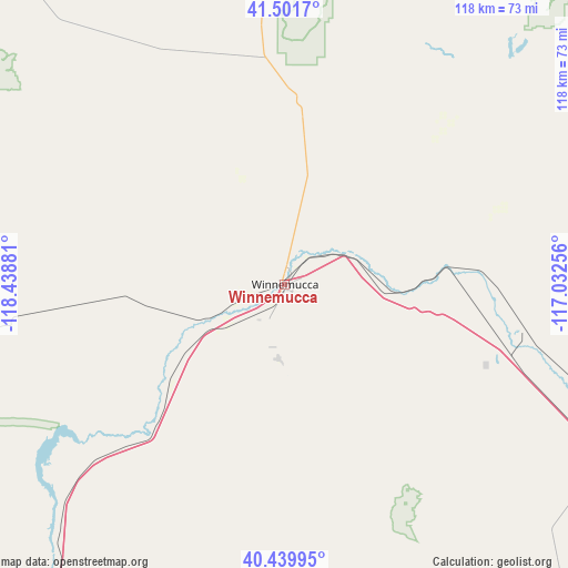
Winnemucca GPS coordinates[2]
40° 58' 22.656" North, 117° 44' 8.448" West
| Map corner | latitude | longitude |
|---|---|---|
| Upper-left | 41.5017°, | -118.43881° |
| Center: | 40.97296°, | -117.73568° |
| Lower-right: | 40.43995°, | -117.03256° |
| Map W x H: | 118.1×118.1 km | = 73.4×73.4mi |
| max Lat: | 71.29058° ⇑34.4% North |
| Winnemucca: | 40.97296° |
| min Lat: | ⇓65.6% South 19.06759° |
| min Long | Winnemucca | max Long |
| -171.73463° | -117.73568° | -66.98998° |
| W 9.4%⇐ | ⇒90.6% E |
Elevation
Elevation of Winnemucca is 1316 m = 4318 ft, and this is 1021.2 m = 3350 ft above average elevation for this country.
| Max E: |
3189 m = 10463 ft | 4.7% |
| Winnemucca | 1316 m 4318 ft | |
| Avg. | 294.8 m = 967 ft | |
Min E: |
-60 m = -197 ft | 95.3% |
See also: United States elevation on elevation.city.
Geographical zone
Winnemucca is located in North temperate zone (between Tropic of Cancer and the Arctic Circle). Distance of this Northern Tropic circle is 1949.8 km =1211.5 mi to South.| Distance of | km | miles | from Winnemucca |
|---|---|---|---|
| North Pole | 5451.3 | 3387.3 | to North |
| Arctic Circle | 2845.4 | 1768 | to North |
| Tropic Cancer | 1949.8 | 1211.5 | to South |
| Equator | 4555.8 | 2830.8 | to South |


Nearby cities:
15 places around Winnemucca: (largest is in red/bold)
• Battle Mountain
76.8 km =47.7 mi,  118°
118°
• Carlin
140.2 km =87.1 mi,  101°
101°
• Cedarville
212.9 km =132.3 mi,  286°
286°
• Elko
166.5 km =103.5 mi, 95°
• Eureka
221.5 km =137.6 mi,  137°
137°
• Fallon
188.7 km =117.3 mi,  207°
207°
• Fallon Station
192.1 km =119.4 mi, 205°
• Fernley
198.9 km =123.6 mi,  220°
220°
• Lovelock
108 km =67.1 mi, 215°
• Osino
174.3 km =108.3 mi,  91°
91°
• Owyhee
174.2 km =108.2 mi,  51°
51°
• Silver Springs
214.4 km =133.2 mi, 216°
• Spanish Springs
222.7 km =138.4 mi,  228°
228°
• Spring Creek
182.9 km =113.6 mi, 98°
• Wadsworth
198.6 km =123.4 mi, 221°
Sources, notices
• [Note1] Compared only with cities in United States existing in our database
• [Src1] Map data: © OpenStreetMap contributors (CC-BY-SA)
• [Src2] Other city data from geonames.org with taken over terms of usage.
• [Src3] Geographical zone / Annual Mean Temperature by Robert A. Rohde @ Wikipedia
