Eureka geodata
Eureka (Nevada) is a seat of a second-order administrative division; located in United States in America/Los_Angeles (GMT-7) time zone. With population of 610 people, there are 19583 cities with bigger population in this country. Compared to other cities in United States, 50.8% of cities are located further ↑North; 89.1% of cities are located further →East and 99.1% of cities have lower elevation than Eureka. Note1


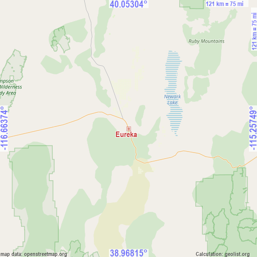
Eureka GPS coordinates[2]
39° 30' 45.756" North, 115° 57' 38.196" West
| Map corner | latitude | longitude |
|---|---|---|
| Upper-left | 40.05304°, | -116.66374° |
| Center: | 39.51271°, | -115.96061° |
| Lower-right: | 38.96815°, | -115.25749° |
| Map W x H: | 120.6×120.6 km | = 74.9×74.9mi |
| max Lat: | 71.29058° ⇑50.8% North |
| Eureka: | 39.51271° |
| min Lat: | ⇓49.2% South 19.06759° |
| min Long | Eureka | max Long |
| -171.73463° | -115.96061° | -66.98998° |
| W 10.9%⇐ | ⇒89.1% E |
Elevation
Elevation of Eureka is 1979 m = 6493 ft, and this is 1684.2 m = 5526 ft above average elevation for this country.
| Max E: |
3189 m = 10463 ft | 0.90000000000001% |
| Eureka | 1979 m 6493 ft | |
| Avg. | 294.8 m = 967 ft | |
Min E: |
-60 m = -197 ft | 99.1% |
See also: United States elevation on elevation.city.
Geographical zone
Eureka is located in North temperate zone (between Tropic of Cancer and the Arctic Circle). Distance of this Northern Tropic circle is 1787.5 km =1110.7 mi to South.| Distance of | km | miles | from Eureka |
|---|---|---|---|
| North Pole | 5613.7 | 3488.2 | to North |
| Arctic Circle | 3007.8 | 1869 | to North |
| Tropic Cancer | 1787.5 | 1110.7 | to South |
| Equator | 4393.4 | 2729.9 | to South |


Nearby cities:
15 places around Eureka: (largest is in red/bold)
• Battle Mountain
150.4 km =93.5 mi,  326°
326°
• Carlin
134.1 km =83.3 mi,  354°
354°
• Elko
147.7 km =91.8 mi,  6°
6°
• Ely
96.7 km =60.1 mi,  107°
107°
• Goldfield
229.2 km =142.4 mi,  208°
208°
• Lovelock
227 km =141.1 mi,  289°
289°
• McGill
102.2 km =63.5 mi,  96°
96°
• Osino
159.9 km =99.4 mi, 9°
• Pioche
219.3 km =136.3 mi,  143°
143°
• Spring Creek
138.7 km =86.2 mi, 13°
• Tonopah
194.8 km =121 mi, 214°
• Wells
196.8 km =122.3 mi,  25°
25°
• Wendover
212.8 km =132.2 mi,  50°
50°
• West Wendover
210.6 km =130.9 mi, 49°
• Winnemucca
221.5 km =137.6 mi,  317°
317°
Sources, notices
• [Note1] Compared only with cities in United States existing in our database
• [Src1] Map data: © OpenStreetMap contributors (CC-BY-SA)
• [Src2] Other city data from geonames.org with taken over terms of usage.
• [Src3] Geographical zone / Annual Mean Temperature by Robert A. Rohde @ Wikipedia
