Cheyenne geodata
Cheyenne (Wyoming) is a seat of a first-order administrative division; located in United States in America/Denver (GMT-6) time zone. With population of 63,335 people, there are 690 cities with bigger population in this country. Compared to other cities in United States, 67.3% of cities are located further ↓South; 83% of cities are located further →East and 98.7% of cities have lower elevation than Cheyenne. Note1


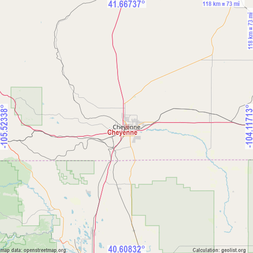
Cheyenne GPS coordinates[2]
41° 8' 23.928" North, 104° 49' 12.9" West
| Map corner | latitude | longitude |
|---|---|---|
| Upper-left | 41.66737°, | -105.52338° |
| Center: | 41.13998°, | -104.82025° |
| Lower-right: | 40.60832°, | -104.11713° |
| Map W x H: | 117.8×117.8 km | = 73.2×73.2mi |
| max Lat: | 71.29058° ⇑32.7% North |
| Cheyenne: | 41.13998° |
| min Lat: | ⇓67.3% South 19.06759° |
| min Long | Cheyenne | max Long |
| -171.73463° | -104.82025° | -66.98998° |
| W 17%⇐ | ⇒83% E |
Elevation
Elevation of Cheyenne is 1866 m = 6122 ft, and this is 1571.2 m = 5155 ft above average elevation for this country.
| Max E: |
3189 m = 10463 ft | 1.3% |
| Cheyenne | 1866 m 6122 ft | |
| Avg. | 294.8 m = 967 ft | |
Min E: |
-60 m = -197 ft | 98.7% |
See also: Cheyenne elevation on elevation.city.
Geographical zone
Cheyenne is located in North temperate zone (between Tropic of Cancer and the Arctic Circle). Distance of this Northern Tropic circle is 1968.4 km =1223.1 mi to South.| Distance of | km | miles | from Cheyenne |
|---|---|---|---|
| North Pole | 5432.7 | 3375.7 | to North |
| Arctic Circle | 2826.8 | 1756.5 | to North |
| Tropic Cancer | 1968.4 | 1223.1 | to South |
| Equator | 4574.3 | 2842.3 | to South |


Nearby cities:
15 places around Cheyenne: (largest is in red/bold)
• Ault
62.4 km =38.8 mi,  173°
173°
• Eaton
68.4 km =42.5 mi, 172°
• Fort Collins
65.6 km =40.8 mi,  199°
199°
• Fox Farm-College
4.3 km =2.7 mi,  136°
136°
• Greeley
80.2 km =49.8 mi, 173°
• Laporte
63.1 km =39.2 mi,  205°
205°
• Laramie
67.2 km =41.8 mi,  286°
286°
• Pierce
56.4 km =35 mi, 174°
• Pine Bluffs
63.1 km =39.2 mi,  85°
85°
• Ranchettes
9.1 km =5.7 mi,  16°
16°
• Severance
68.5 km =42.6 mi,  182°
182°
• South Greeley
4.9 km =3 mi, 166°
• Timnath
69.3 km =43.1 mi,  191°
191°
• Wellington
51 km =31.7 mi, 198°
• Windsor
74 km =46 mi, 185°
Sources, notices
• [Note1] Compared only with cities in United States existing in our database
• [Src1] Map data: © OpenStreetMap contributors (CC-BY-SA)
• [Src2] Other city data from geonames.org with taken over terms of usage.
• [Src3] Geographical zone / Annual Mean Temperature by Robert A. Rohde @ Wikipedia
