Fox Farm-College geodata
Fox Farm-College (Wyoming) is a populated place; located in United States in America/Denver (GMT-6) time zone. With population of 3,647 people, there are 8661 cities with bigger population in this country. Compared to other cities in United States, 67% of cities are located further ↓South; 83% of cities are located further →East and 98.5% of cities have lower elevation than Fox Farm-College. Note1


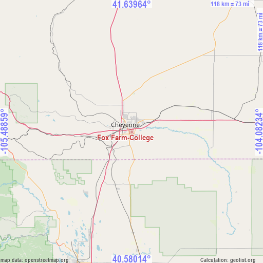
Fox Farm-College GPS coordinates[2]
41° 6' 43.308" North, 104° 47' 7.656" West
| Map corner | latitude | longitude |
|---|---|---|
| Upper-left | 41.63964°, | -105.48859° |
| Center: | 41.11203°, | -104.78546° |
| Lower-right: | 40.58014°, | -104.08234° |
| Map W x H: | 117.8×117.8 km | = 73.2×73.2mi |
| max Lat: | 71.29058° ⇑33% North |
| Fox Farm-College: | 41.11203° |
| min Lat: | ⇓67% South 19.06759° |
| min Long | Fox Farm-Colleg | max Long |
| -171.73463° | -104.78546° | -66.98998° |
| W 17%⇐ | ⇒83% E |
Elevation
Elevation of Fox Farm-College is 1828 m = 5997 ft, and this is 1533.2 m = 5030 ft above average elevation for this country.
| Max E: |
3189 m = 10463 ft | 1.5% |
| Fox Farm-College | 1828 m 5997 ft | |
| Avg. | 294.8 m = 967 ft | |
Min E: |
-60 m = -197 ft | 98.5% |
See also: United States elevation on elevation.city.
Geographical zone
Fox Farm-College is located in North temperate zone (between Tropic of Cancer and the Arctic Circle). Distance of this Northern Tropic circle is 1965.3 km =1221.2 mi to South.| Distance of | km | miles | from Fox Farm-College |
|---|---|---|---|
| North Pole | 5435.8 | 3377.6 | to North |
| Arctic Circle | 2829.9 | 1758.4 | to North |
| Tropic Cancer | 1965.3 | 1221.2 | to South |
| Equator | 4571.2 | 2840.4 | to South |


Nearby cities:
15 places around Fox Farm-College: (largest is in red/bold)
• Ault
59.1 km =36.7 mi,  175°
175°
• Cheyenne
4.3 km =2.7 mi,  316°
316°
• Eaton
65 km =40.4 mi,  174°
174°
• Fort Collins
63.7 km =39.6 mi,  203°
203°
• Greeley
76.8 km =47.7 mi, 175°
• Laporte
61.7 km =38.3 mi,  208°
208°
• Laramie
70.9 km =44.1 mi,  288°
288°
• Pierce
53 km =32.9 mi, 177°
• Pine Bluffs
60.5 km =37.6 mi,  82°
82°
• Ranchettes
11.9 km =7.4 mi,  358°
358°
• Severance
65.6 km =40.8 mi, 184°
• South Greeley
2.4 km =1.5 mi,  226°
226°
• Timnath
67 km =41.6 mi,  194°
194°
• Wellington
49.1 km =30.5 mi, 202°
• Windsor
71.2 km =44.2 mi, 187°
Sources, notices
• [Note1] Compared only with cities in United States existing in our database
• [Src1] Map data: © OpenStreetMap contributors (CC-BY-SA)
• [Src2] Other city data from geonames.org with taken over terms of usage.
• [Src3] Geographical zone / Annual Mean Temperature by Robert A. Rohde @ Wikipedia
