South Greeley geodata
South Greeley (Wyoming) is a populated place; located in United States in America/Denver (GMT-6) time zone. With population of 4,217 people, there are 7957 cities with bigger population in this country. Compared to other cities in United States, 66.8% of cities are located further ↓South; 83% of cities are located further →East and 98.6% of cities have lower elevation than South Greeley. Note1


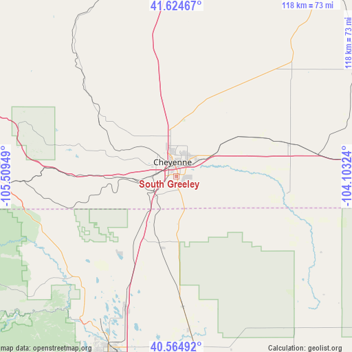
South Greeley GPS coordinates[2]
41° 5' 48.948" North, 104° 48' 22.896" West
| Map corner | latitude | longitude |
|---|---|---|
| Upper-left | 41.62467°, | -105.50949° |
| Center: | 41.09693°, | -104.80636° |
| Lower-right: | 40.56492°, | -104.10324° |
| Map W x H: | 117.8×117.8 km | = 73.2×73.2mi |
| max Lat: | 71.29058° ⇑33.2% North |
| South Greeley: | 41.09693° |
| min Lat: | ⇓66.8% South 19.06759° |
| min Long | South Greeley | max Long |
| -171.73463° | -104.80636° | -66.98998° |
| W 17%⇐ | ⇒83% E |
Elevation
Elevation of South Greeley is 1845 m = 6053 ft, and this is 1550.2 m = 5086 ft above average elevation for this country.
| Max E: |
3189 m = 10463 ft | 1.4% |
| South Greeley | 1845 m 6053 ft | |
| Avg. | 294.8 m = 967 ft | |
Min E: |
-60 m = -197 ft | 98.6% |
See also: United States elevation on elevation.city.
Geographical zone
South Greeley is located in North temperate zone (between Tropic of Cancer and the Arctic Circle). Distance of this Northern Tropic circle is 1963.6 km =1220.1 mi to South.| Distance of | km | miles | from South Greeley |
|---|---|---|---|
| North Pole | 5437.5 | 3378.7 | to North |
| Arctic Circle | 2831.6 | 1759.5 | to North |
| Tropic Cancer | 1963.6 | 1220.1 | to South |
| Equator | 4569.6 | 2839.4 | to South |


Nearby cities:
15 places around South Greeley: (largest is in red/bold)
• Ault
57.5 km =35.7 mi,  173°
173°
• Cheyenne
4.9 km =3 mi,  346°
346°
• Eaton
63.5 km =39.5 mi, 172°
• Fort Collins
61.5 km =38.2 mi,  202°
202°
• Fox Farm-College
2.4 km =1.5 mi,  46°
46°
• Greeley
75.3 km =46.8 mi, 173°
• Laporte
59.3 km =36.8 mi,  208°
208°
• Laramie
69.8 km =43.4 mi,  289°
289°
• Pierce
51.5 km =32 mi,  175°
175°
• Pine Bluffs
62.5 km =38.8 mi,  81°
81°
• Ranchettes
13.6 km =8.5 mi,  5°
5°
• Severance
63.8 km =39.6 mi, 183°
• Timnath
64.9 km =40.3 mi,  193°
193°
• Wellington
46.9 km =29.1 mi, 201°
• Windsor
69.3 km =43.1 mi, 186°
Sources, notices
• [Note1] Compared only with cities in United States existing in our database
• [Src1] Map data: © OpenStreetMap contributors (CC-BY-SA)
• [Src2] Other city data from geonames.org with taken over terms of usage.
• [Src3] Geographical zone / Annual Mean Temperature by Robert A. Rohde @ Wikipedia
