Pupukea geodata
Pupukea (Hawaii) is a populated place; located in United States in Pacific/Honolulu (GMT-10) time zone. With population of 4,551 people, there are 7592 cities with bigger population in this country. Compared to other cities in United States, 99.5% of cities are located further ↑North; 99.7% of cities are located further →East and 91.5% of cities have higher elevation than Pupukea. Note1


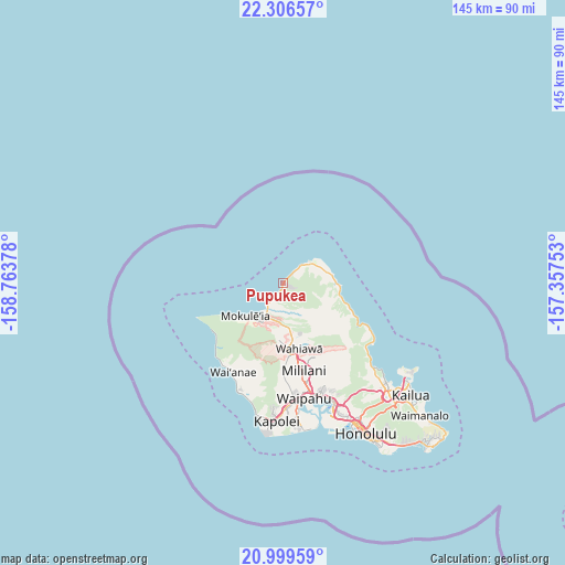
Pupukea GPS coordinates[2]
21° 39' 16.416" North, 158° 3' 38.34" West
| Map corner | latitude | longitude |
|---|---|---|
| Upper-left | 22.30657°, | -158.76378° |
| Center: | 21.65456°, | -158.06065° |
| Lower-right: | 20.99959°, | -157.35753° |
| Map W x H: | 145.3×145.3 km | = 90.3×90.3mi |
| max Lat: | 71.29058° ⇑99.5% North |
| Pupukea: | 21.65456° |
| min Lat: | ⇓0.5% South 19.06759° |
| min Long | Pupukea | max Long |
| -171.73463° | -158.06065° | -66.98998° |
| W 0.3%⇐ | ⇒99.7% E |
Elevation
Elevation of Pupukea is 13 m = 43 ft, and this is 281.8 m = 925 ft below average elevation for this country.
| Max E: |
3189 m = 10463 ft | 91.5% |
| Avg. | 294.8 m = 967 ft | |
| Pupukea | 13 m = 43 ft | |
Min E: |
-60 m = -197 ft | 8.5% |
See also: United States elevation on elevation.city.
Geographical zone
Pupukea is located in North Torrid zone (between Equator and Tropic of Cancer). Distance of this Northern Tropic circle is 198.2 km =123.2 mi to North.| Distance of | km | miles | from Pupukea |
|---|---|---|---|
| North Pole | 7599.3 | 4722 | to North |
| Arctic Circle | 4993.4 | 3102.8 | to North |
| Tropic Cancer | 198.2 | 123.2 | to North |
| Equator | 2407.8 | 1496.1 | to South |


Nearby cities:
15 places around Pupukea: (largest is in red/bold)
• Hale‘iwa
8.2 km =5.1 mi,  212°
212°
• Hau‘ula
16.6 km =10.3 mi,  108°
108°
• Kahuku
11.6 km =7.2 mi,  75°
75°
• Ka‘a‘awa
24.4 km =15.2 mi,  117°
117°
• Lā‘ie
14.3 km =8.9 mi,  94°
94°
• Mililani Town
23.6 km =14.7 mi,  164°
164°
• Mokulēia
12.7 km =7.9 mi,  228°
228°
• Mākaha Valley
24.5 km =15.2 mi,  215°
215°
• Punaluu
20.8 km =12.9 mi, 115°
• Punalu‘u
21.3 km =13.2 mi, 116°
• Schofield Barracks
17.4 km =10.8 mi,  181°
181°
• Wahiawā
17.3 km =10.7 mi,  167°
167°
• Waialua
11.3 km =7 mi, 220°
• Waipi‘o Acres
21.7 km =13.5 mi, 166°
• Whitmore Village
16 km =9.9 mi, 166°
Sources, notices
• [Note1] Compared only with cities in United States existing in our database
• [Src1] Map data: © OpenStreetMap contributors (CC-BY-SA)
• [Src2] Other city data from geonames.org with taken over terms of usage.
• [Src3] Geographical zone / Annual Mean Temperature by Robert A. Rohde @ Wikipedia
